Introduction
Mashhad metropolis, as the second most populous metropolitan area in Iran, is located in a region characterized by moderate-to-high seismic hazard. Active faults surrounding the city make the occurrence of a destructive earthquake a serious and persistent threat (Maroufi et al., 2022). Moreover, a substantial proportion of the city’s residential fabric consists of mid-rise and high-rise apartment buildings, which accommodate millions of residents. The traditional approach to earthquake engineering, focused solely on preventing building collapse and protecting human life, is insufficient for a city of this scale. Even when buildings do not collapse, structural and nonstructural damage may prolong disruption of habitation, impose substantial reconstruction costs, and paralyze the city’s social and economic functions (Walker et al., 2014). Therefore, the transition from seismic resistance to seismic resilience has become an unavoidable necessity in managing the risk faced by this metropolis.
According to (Brune et al., 2003) definition, seismic resilience refers to the ability of a system to reduce the likelihood of collapse, absorb the impacts of a seismic event, and rapidly and efficiently recover to an acceptable level of performance (Brune et al., 2003). This capacity is founded on four principal pillars: enhancing strength and performance, providing redundancy and alternative components, mobilizing resources, and ensuring rapid recovery (Cutter et al., 2003).
To measure the various dimensions of resilience, a set of quantitative and qualitative criteria is defined, collectively referred to as resilience indicators. In general, seismic resilience indicators are classified into five dimensions: physical–structural, infrastructural–urban, economic, social, and managerial–institutional (Sinha et al., 2016).
Previous studies in the field of seismic resilience have primarily focused on structural indicators or macro-level urban indicators (Dodanwala et al., 2024), while overlooking the critical role of criteria such as social capital, residents’ preparedness, the effectiveness of crisis management, and access to emergency services (Chee Yin, et al., 2022). Accordingly, the lack of an integrated, multicriteria framework for assessing resilience at the scale of conventional residential buildings, with the simultaneous consideration of all nonstructural dimensions, remains a significant research need (Kim et al., 2024; Anwar, 2020).
In addition to identifying, weighting, and prioritizing the indicators influencing resilience across the five aforementioned dimensions in order to provide a comprehensive and realistic representation of the seismic resilience of residential apartment buildings, the present study seeks to contextualize this concept within the geographical setting of Mashhad City, taking into account its specific sociocultural conditions. Furthermore, the use of multicriteria assessment methods as a practical decision-making tool for ranking buildings by resilience—providing planners and policymakers with objective and quantitative outputs—constitutes another major innovation and original contribution of this research.
This study ranks the seismic resilience of residential apartment buildings in Mashhad City using a comprehensive multicriteria framework. Given the growing importance of urban resilience to earthquakes, this study seeks to provide an accurate picture of the existing situation and identify the factors influencing it. To achieve this objective, three fundamental questions are addressed. First, what are the key criteria and indicators influencing the seismic resilience of residential apartment buildings in Mashhad City? Second, what are the relative weights and importance of these criteria and indicators, and to what extent does each contribute to overall resilience? Third, what is the current resilience status of the sampled apartment buildings based on the identified resilience indicators, and what strengths, weaknesses, and improvement strategies can be identified?
Accordingly, the research hypotheses are as follows. First, the seismic resilience of residential apartment buildings in Mashhad City is not limited solely to structural safety but is also influenced by multiple other factors, including social, economic, and environmental factors. Second, a significant relationship exists between building resilience and variables such as the number of floors, urban district, residential unit floor area, household size, and distance from emergency and crisis-management centers. Examining these relationships can improve understanding of resilience and support the development of more appropriate strategies.
The findings of this study will provide crisis-management authorities with an effective tool for identifying and prioritizing vulnerable neighborhoods and buildings, thereby facilitating the optimal allocation of seismic-retrofitting budgets. These findings may contribute to the development of a strategic urban-planning document and, by incorporating resilience criteria into construction regulations and detailed urban plans, provide a foundation for safer urban development. They may also facilitate the prediction of potential losses, the response time required, and the resources needed for post-earthquake reconstruction—factors vital for relief and emergency-response organizations. In addition, the results may serve as a basis for designing and implementing educational campaigns aimed at increasing public awareness and enhancing citizens’ preparedness for earthquakes.
This study encountered several limitations, including the difficulty of quantifying certain qualitative indicators, such as social capital and neighborhood cohesion, which require indirect measurement approaches; the dependence of the data on the accuracy and transparency of respondents’ answers; and the need for interdisciplinary expertise to conduct a comprehensive analysis of the data.
Following this introduction, the next section reviews the theoretical foundations and previous research. Subsequently, the research methodology and the procedures used for data collection and multicriteria analysis are described. The Findings section presents and analyzes the results, followed by the Discussion and Conclusions.
Literature review
Theoretical foundations
In recent decades, the approach to natural-disaster risk management has shifted from an exclusive focus on vulnerability reduction toward resilience enhancement (Adger et al., 2005). As a holistic paradigm, resilience emphasizes not only the resistance of structures to earthquake forces but also the ability of a system to absorb shocks, adapt to changing conditions, and rapidly return to an acceptable level of functionality (Proag, 2014). Although resilience has been defined in various ways across scientific disciplines, the common core of these definitions lies in the capacity of a system to cope with disruptions, maintain its primary functions, and recover rapidly and effectively (Alberti, 2005).
Accordingly, seismic resilience may be more specifically defined as the capacity of a community’s social, economic, physical, and managerial systems to anticipate, withstand, and reduce the impacts of an earthquake, as well as their ability to recover, reconstruct, and return to normal conditions—or even improve upon pre-event conditions—as quickly as possible, with the lowest possible costs and social consequences (Kärrholm et al., 2014).
Studies have demonstrated that resilience is a multidimensional phenomenon. One of the most influential theoretical frameworks emphasizing the various dimensions of resilience is the Brune model. This framework, which guides the methodology of the present study, identifies the following principal dimensions (Brune et al., 2003):
● Technical resilience: This refers to the ability of physical systems and infrastructure to withstand an earthquake and maintain their functionality (Boon et al., 2012). Its indicators include the quality of construction materials, compliance with building codes, structural ductility, and related factors.
● Economic resilience: This concerns the capacity of a community’s economic system to absorb earthquake-related losses and rapidly return to normal economic activities (Michel et al., 2014). Relevant indicators include access to insurance coverage and the occupational and income diversity of residents.
● Social resilience: This refers to social capital, place attachment, public awareness, and the capacity of local communities to cooperate and provide mutual assistance during periods of crisis and reconstruction (Adger, 2000). This dimension assesses indicators, such as social cohesion, educational attainment, and awareness of earthquake risks.
● Organizational resilience: This dimension addresses the capacity of responsible organizations and institutions to plan, coordinate, and effectively manage emergency response under crisis conditions (Klein et al., 2003). Indicators such as the speed of emergency assistance and the availability of evacuation and temporary-shelter plans fall within this category.
Taken together, these dimensions constitute a general framework for comprehensively assessing resilience. However, given the broad scope of the physical dimension, and depending on the objectives of the study, it may be examined in two separate domains: the physical domain, which is associated with buildings, and the infrastructural domain, which is related to urban utilities and facilities.
The precise identification of the dimensions and domains directly and indirectly affected by earthquake hazards makes it possible to define and measure quantitative and qualitative indicators to assess the degree of vulnerability in each domain. These indicators can evaluate various forms of vulnerability, including the physical vulnerability of buildings, the vulnerability of critical infrastructure, and economic and social vulnerability. The integrated and systematic analysis of these indicators, together with the determination of the relative weight and importance of each indicator based on local conditions and demographic characteristics, operationalizes the process of identifying the key factors contributing to enhanced seismic resilience.
By providing a comprehensive perspective on the key factors influencing resilience, this integrated approach facilitates the development and implementation of effective and targeted programs to reduce vulnerability and enhance earthquake preparedness. Ultimately, it can contribute to reducing the human and financial losses caused by this natural hazard.
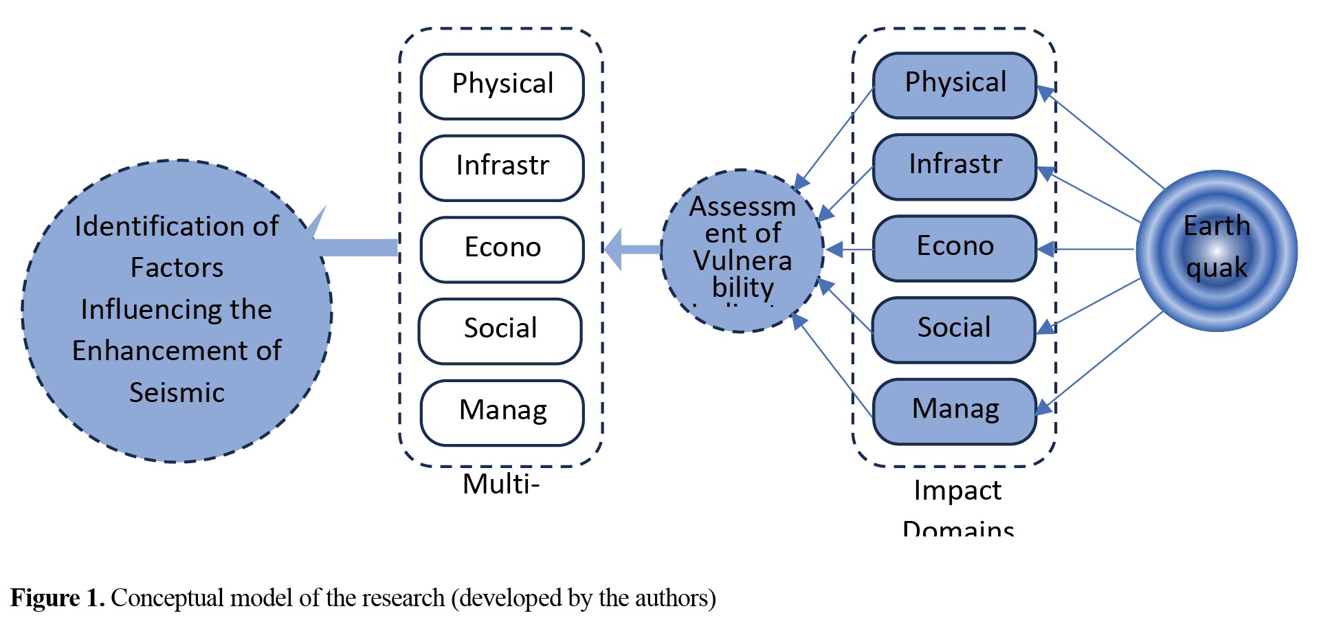
Figure 1 illustrates the conceptual model of this comprehensive and integrated process, presenting the relationships among the various indicators and their effects on resilience.
Review of previous research
Early studies focused primarily on physical resilience and the assessment of structural vulnerability. Gradually, with the development of frameworks such as the Brune model (Brune et al., 2003) and Cutter’s community resilience model (Cutter et al., 2003), research shifted toward a more comprehensive perspective and the quantification of various dimensions of resilience. Applying multicriteria decision analysis to assess and weight different indicators can provide an operational approach for identifying and better understanding of resilience.
In Iran, although numerous studies have examined the seismic vulnerability of cities and deteriorated urban areas, the concept of resilience—particularly from a multidimensional perspective—remains relatively new. Most existing studies have focused on a specific dimension, primarily physical characteristics. Moreover, despite the fact that residential land use accounts for approximately 50% of the total urban land-use area on average and represents the most important and sensitive domain in any city, many studies conducted at the metropolitan scale have failed to consider the specific characteristics of different types of residential fabrics—including historic and newly developed areas, as well as apartment-based and detached housing—their physical conditions, and the economic, social, and other circumstances governing them (Amanpour et al., 2016).
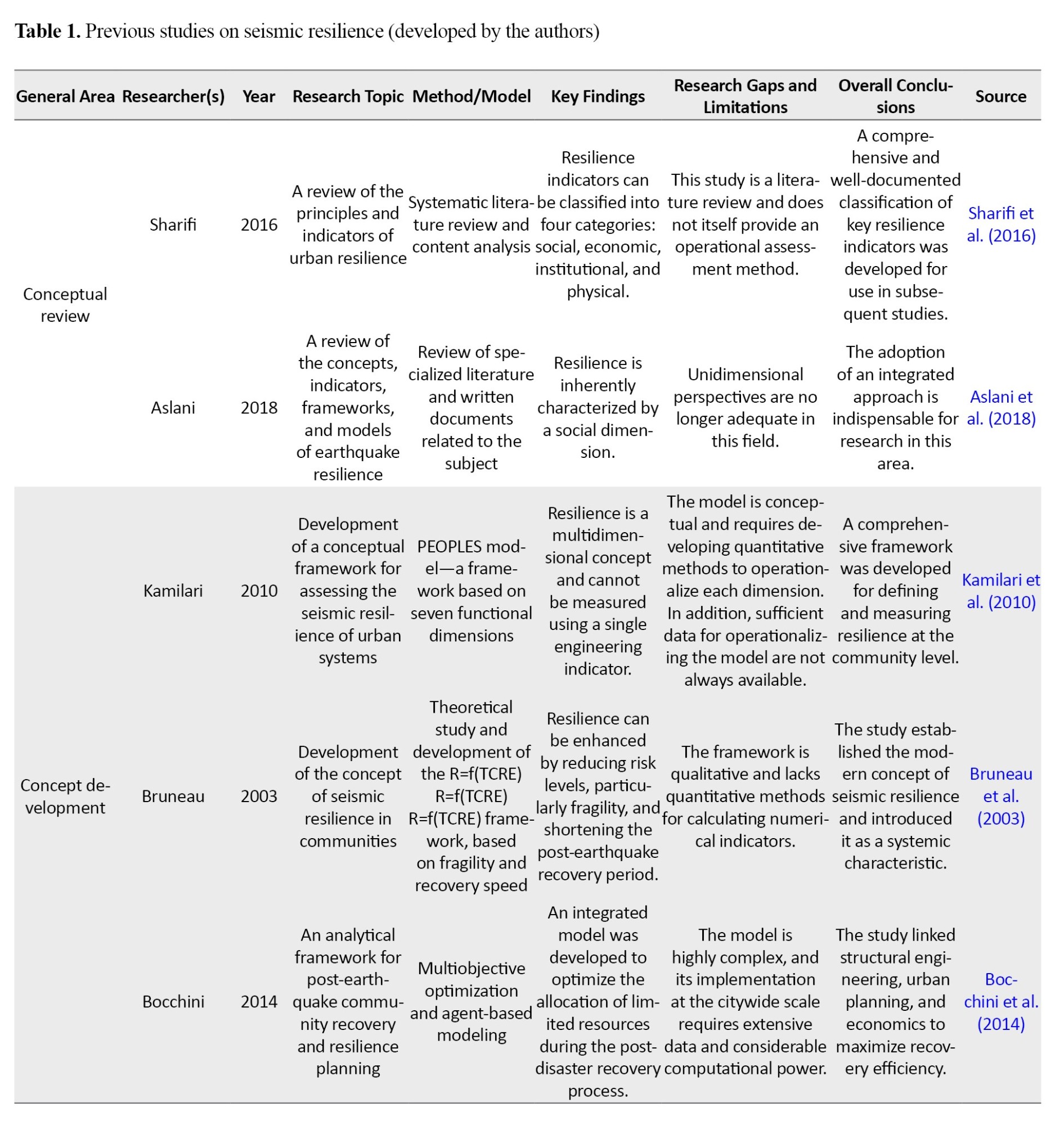
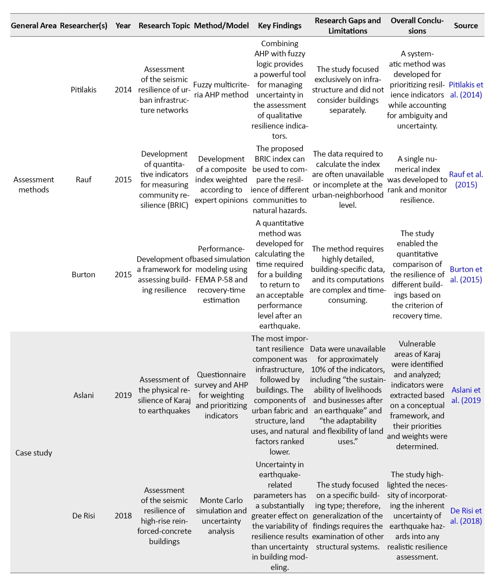
Table 1 presents some of the most important studies conducted on the assessment of seismic resilience in residential buildings.
A review of the relevant literature reveals several research gaps that the present study seeks to address. First, there is a clear shortage of integrated models for assessing resilience at the micro scale, particularly at the building level. Most existing models operate at the metropolitan or regional scale and do not facilitate the assessment and comparison of individual residential units. Second, comprehensive studies that simultaneously address the various dimensions of resilience in apartment-based residential environments, particularly within Iran’s urban context, remain limited. These dimensions have generally been examined separately rather than through an integrated framework. Third, the lack of comparative studies across different residential fabrics within a single city has hindered an understanding of the differences, strengths, and weaknesses of each fabric in confronting earthquake hazards. For example, no systematic assessment based on a consistent methodology has yet compared the seismic resilience of buildings in historic neighborhoods with that of buildings in intermediate and newly developed urban areas within a city, such as Mashhad. Fourth, contextualizing and weighing resilience indicators is crucial, since many indicators incorporated into global models are not fully compatible with Iran’s cultural, social, and economic conditions. Therefore, identifying and weighting localized indicators that accurately reflect the realities of Iranian society constitutes a fundamental research need and gap that the present study seeks to address.
Applying a multicriteria analysis approach to assess the seismic resilience of residential apartments in Mashhad City is an innovative and multifaceted necessity that extends beyond the limitations of traditional studies. Such studies have often focused exclusively on physical characteristics and have consequently failed to develop a comprehensive assessment of resilience dimensions within the context of building as dynamic social–physical systems. By incorporating diverse indicators from multiple resilience dimensions within the context of Mashhad City, the multicriteria approach enables a more comprehensive assessment. It also facilitates comparisons among the city’s different residential fabrics. By assigning appropriate weights to the indicators, the resilience of buildings in each area can be measured separately and compared with that of other areas or building groups.
For example, a newly constructed building may exhibit favorable physical conditions but perform poorly in the social dimension because of weak social cohesion among its residents. This type of comparative analysis provides valuable information for urban planning and the optimal allocation of crisis-management resources. In addition, multicriteria methods, by determining the relative weight and importance of each indicator, help identify the most influential factors affecting resilience in each area. This enables urban managers to focus on strengthening key indicators in accordance with the specific characteristics of each area rather than implementing broad and costly programs. For instance, seismic resilience in one area may be improved by prioritizing social education and preparedness programs, whereas in another area, greater emphasis may be placed on structural renewal and seismic retrofitting.
Study area
Mashhad, the administrative center of Khorasan Razavi Province, with a population exceeding 3.5 million according to the 2026 census, is the second most populous metropolis in Iran. The city is situated on a plain between 59°15′ and 60°36′ East longitude and 35°43′ and 37°08′ North latitude, covering more than 400 square kilometers (Peyravi et al., 2020). The urban fabric of Mashhad City is highly heterogeneous, comprising a mosaic of deteriorated historical quarters, intermediate zones with moderate building density, and newly developed, high-density residential districts. This pronounced diversity in terms of residents’ socioeconomic status, construction quality, and building age makes Mashhad City an ideal case study for assessing urban seismic resilience.
Moreover, Mashhad City is located in a high-seismicity zone and has historically experienced devastating earthquakes. The most prominent historical event was the 1673 earthquake (1084 AH), with an estimated magnitude of approximately 6.5, which caused widespread destruction across the city and resulted in thousands of fatalities (Moghadas et al., 2018). Other historical and instrumentally recorded seismic events in the surrounding areas further corroborate the active tectonic nature of this fault zone. The primary source of seismic hazard in the city is the Mashhad Fault (Shad et al., 2020), which trends northwest–southeast over a length of approximately 150 km, passing through the central and southern parts of the metropolis. Geological and seismotectonic investigations confirm that this fault is active and capable of generating an earthquake with an estimated magnitude of up to 7.0 (Hayati et al., 2015).
To account for this urban and spatial heterogeneity, case study buildings were selected through a purposive and clustered sampling scheme across neighborhoods with distinct urban characteristics. Consequently, samples were drawn from two broad categories: central deteriorated urban fabrics and intermediate/newly developed areas. The central districts are primarily characterized by fine-grained urban fabrics, narrow access passages, high population densities, deteriorated building stock, comparatively lower socioeconomic profiles, and a severe deficit of open and refuge spaces. These quarters represent areas with the highest intrinsic seismic vulnerability. Conversely, the intermediate and newly developed districts feature modern apartment complexes, wider road networks, superior access to public services and urban green spaces, and residents of middle-to-high socioeconomic status, representing semi-regular, planned fabrics with moderate-to-high levels of resilience.
The case studies were selected via a systematic, multicriteria procedure to facilitate an operational and empirical assessment of seismic resilience. This selection accounted for physical, infrastructural, economic, social, and managerial–institutional dimensions. The sampling strategy employed a hybrid approach combining stratified, cluster, and random sampling techniques. In the initial stage, the city was categorized into relatively homogeneous spatial zones based on the aforementioned dimensions, yielding two principal fabric typologies (deteriorated fabrics vs. intermediate/newly developed fabrics). Representative neighborhoods were then selected as sampling clusters from each typology. Finally, individual residential apartment buildings were randomly selected within each cluster for in-depth assessment. This hybrid sampling framework ensures adequate representation of the diverse urban typologies, thereby enhancing the internal validity and generalizability of the resilience assessment findings.
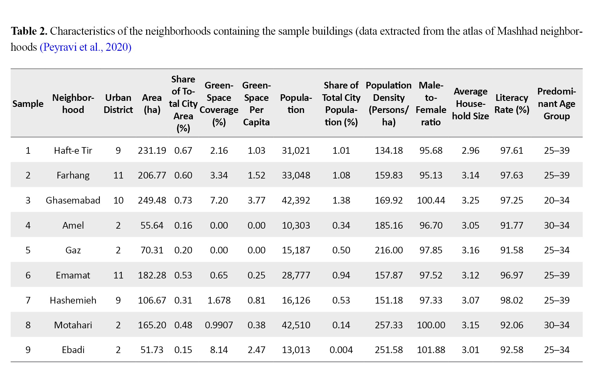
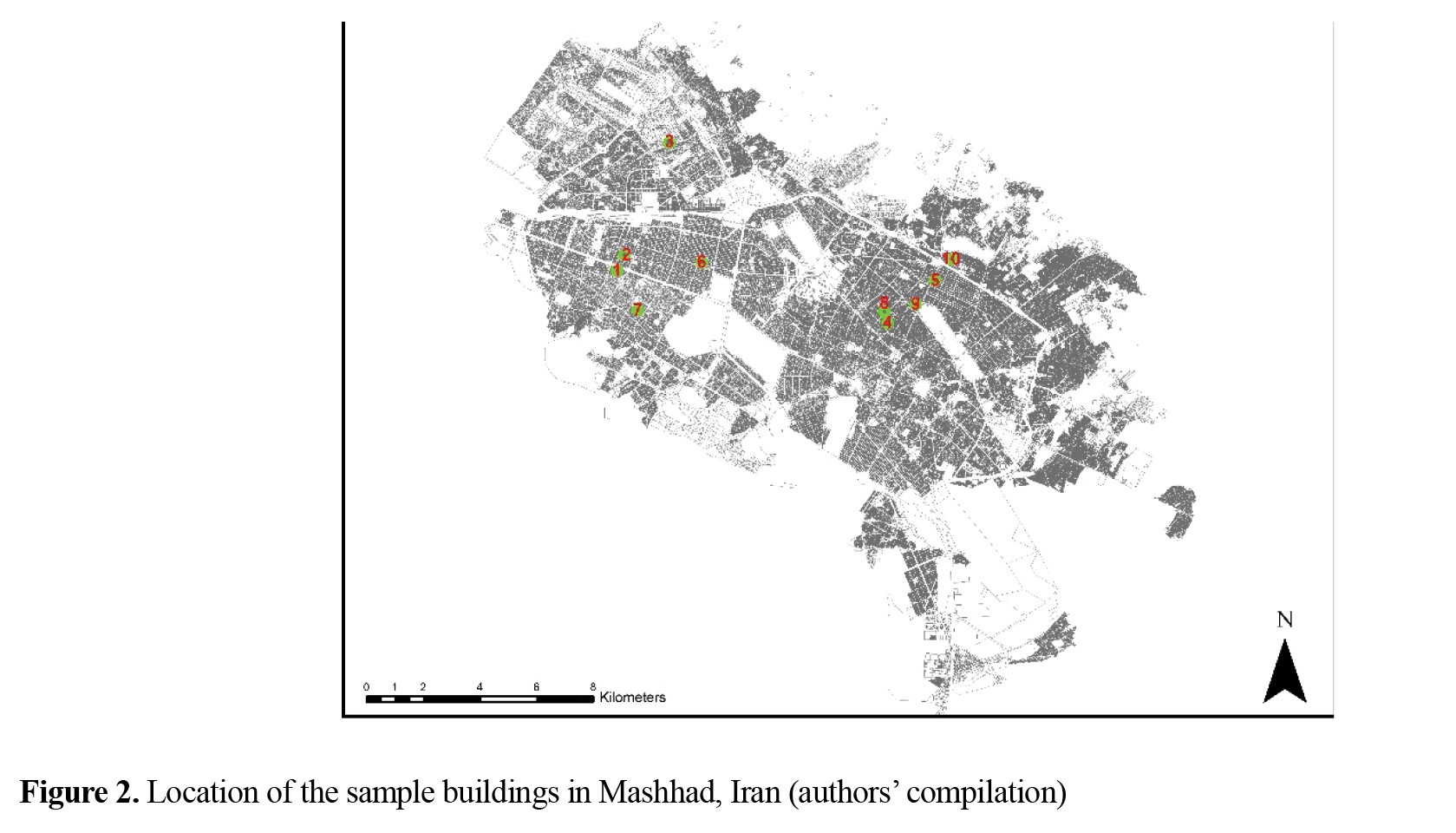
Table 2 presents the general characteristics of the districts encompassing the selected case studies, and
Figure 2 shows their spatial distribution across the city.
Materials and Methods
Indicators and variables
The multidimensional concept of resilience in the face of seismic hazards can be adequately described only by selecting an appropriate set of influential variables. Accordingly, this study considered five categories of indicators: physical, infrastructural, economic, social, and managerial characteristics. Statistical methods were then employed to identify the variables affecting integrated seismic resilience.
The first step in the methodological framework involved identifying and integrating the relevant data to establish a comprehensive assessment platform (
Table 3).
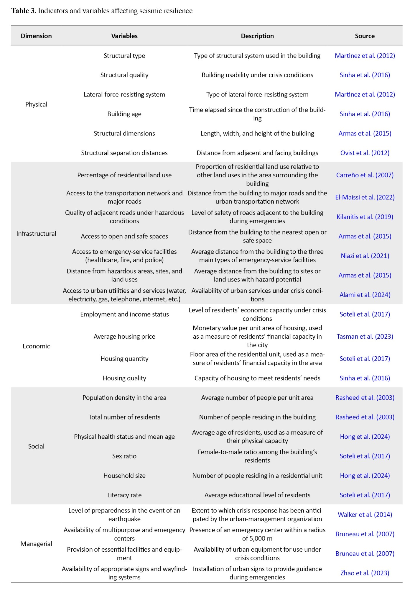
From the physical perspective, seismic resilience encompasses the structural characteristics of buildings. From the infrastructural perspective, it depends on the facilities and capacities available under hazardous conditions, including the spatial configuration and quality of transportation infrastructure, which determine accessibility to hospitals and emergency-management stations. In addition, the economic dimension of seismic resilience is associated with the capacity to cope with and recover from a crisis, as well as the value of assets potentially exposed to damage in the event of a hazard. From the social perspective, seismic resilience includes the total number and proportion of vulnerable populations exposed to risk. Finally, the managerial dimension depends on the capacity to provide emergency services, reduce damage, and prevent the escalation of hazardous conditions.
Data collection
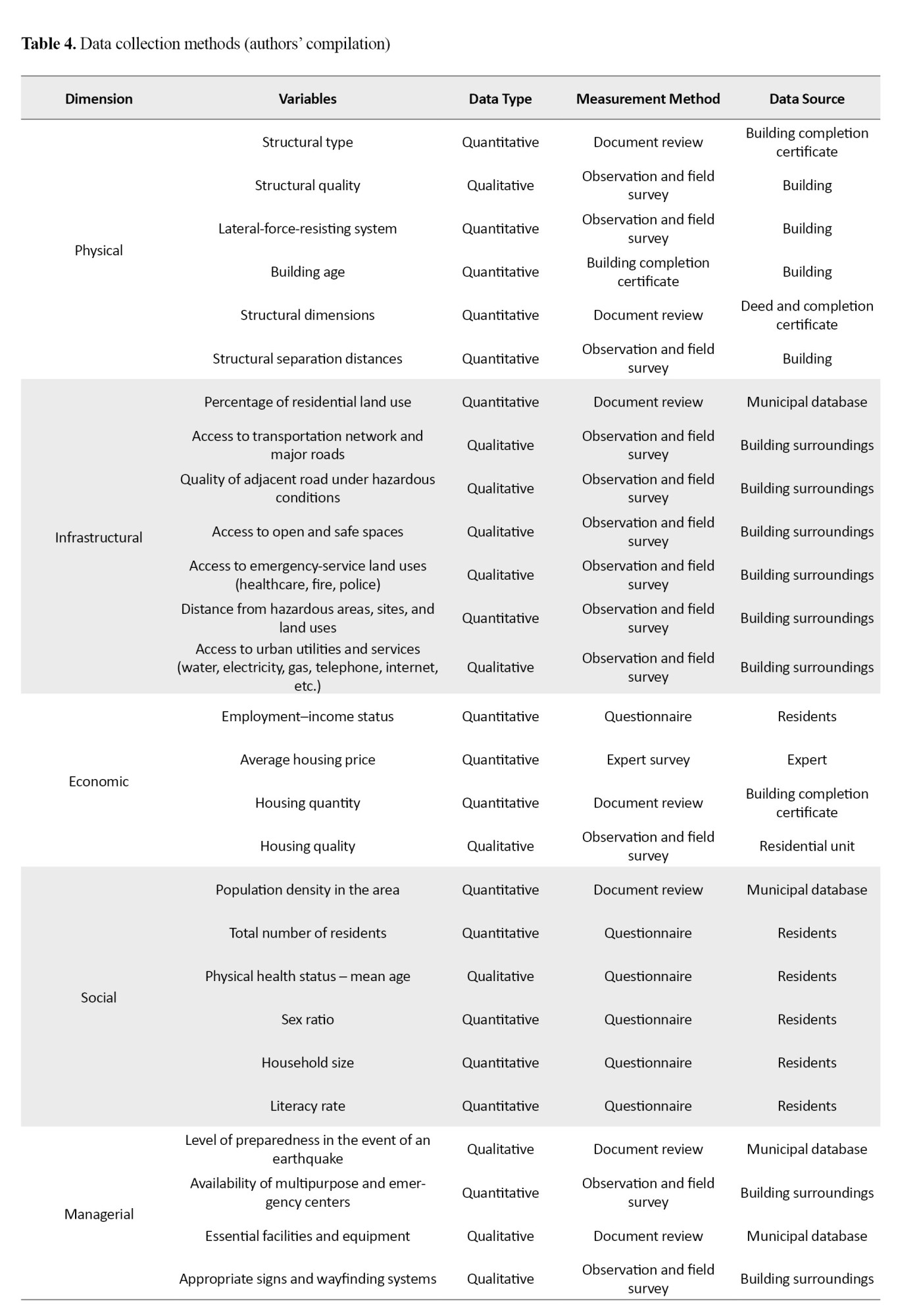
The final variables comprised six physical, seven infrastructural, four economic, six social, and four managerial variables. Data for these variables were collected through field observation and investigation, consultation of municipal databases and official government documents, face-to-face interviews using a structured questionnaire, and an expert survey.
Table 4 presents the data-collection method and source of information for each variable.
 Physical variables
Physical data were collected at two levels: the building level and the surrounding-environment level. To obtain accurate, reliable building-level data, information related to the physical characteristics of the buildings was extracted by examining and analyzing official building completion certificates. This approach provided access to comprehensive information, including floor area, number of stories, and other technical specifications.
Conversely, variables associated with the environment surrounding each building were assessed and recorded through direct observation and field investigations. This method enabled the collection of information on interbuilding distances and comprehensive conditions and characteristics of the buildings’ surroundings. Accordingly, this dual approach produced a comprehensive, integrated dataset of physical characteristics at both the building and environmental levels, providing the basis for subsequent analyses and assessments.
Infrastructural variables
Data collection for the infrastructural variables relied on two primary sources: first, the information available in the comprehensive municipal database; and second, detailed observations and field investigations conducted within a 100-m radius of each study building. This dual-source approach was adopted to ensure the accuracy and comprehensiveness of the information.
Nevertheless, whenever discrepancies were identified between the data recorded in the municipal information system and the conditions observed in the field—particularly with respect to road conditions, urban infrastructure such as water, electricity, and gas networks, and facilities surrounding the sample buildings—the existing conditions and findings obtained through field observations were treated as the primary basis for analysis and assessment. This decision was based on the assumption that current on-site conditions provide a more accurate and up-to-date representation of the area’s infrastructure and therefore constitute a more reliable basis for subsequent analyses and the development of context-sensitive recommendations.
Economic variables
In the economic dimension, data were collected using several complementary methods to provide a comprehensive and accurate representation of existing conditions. Information on the employment–income variable was obtained through the design and administration of standardized questionnaires. Average housing prices were estimated through a survey of experienced experts active in the housing market. Housing quantity was determined based on information obtained from building completion certificates. Finally, housing quality was assessed through direct observation and field investigation.
Social variables
For the social dimension, data on population density at the neighborhood level were obtained from the municipal information database, while the remaining social variables were collected through questionnaires. The questionnaire identified the social characteristics of residents in the study buildings. Accordingly, the statistical population consisted of residents of the selected buildings, and purposive, non-probability sampling was employed.
Respondents ranged in age from 14 to 76 years, and all resided in the buildings under investigation. The questions were designed as closed-ended items to generate quantitative data, with predefined response options based on a Likert scale. Cronbach’s alpha was used to evaluate the reliability and internal consistency of the questionnaire.
In total, 98 structured interviews focusing on residents’ social characteristics were conducted.
Table 3 presents the characteristics examined, including sex, age, health status, literacy level, and economic conditions. Section 4.4 (Sample Selection) provides further details on the statistical population, while Section 4.5 (Data Analysis) describes the statistical analysis procedures.
Managerial variables
For the managerial dimension, data related to the research variables were collected through two procedures. Information concerning the level of urban-management preparedness for earthquakes, including the availability of essential facilities and equipment, was extracted from the comprehensive municipal database. Information on the availability of multipurpose centers, as well as appropriate signs and wayfinding systems to facilitate rapid and easy access to these centers, was collected through direct observation and detailed field investigations.
In accordance with the objective of the study, data for the physical, infrastructural, economic, social, and managerial dimensions were collected through the following methods: 12 variables through field observation and investigation, four variables from the municipal database, four variables from official government documents, six variables through face-to-face interviews with residents, and one variable through an expert survey (
Table 4).
Data processing
To convert the collected data into a manageable dataset and facilitate its representation, examination, and analysis, the data processing procedure was carried out with precision and close attention. In this regard, Microsoft Excel (2021) was used as the primary data management tool. Specifically, a comprehensive profile was created for each building sample, and all initial raw data, including the values of 27 predefined variables, were recorded and documented therein. These structured profiles provided a reliable information source for precise, in-depth analyses in the subsequent stages of the study.
Data cleaning and management of missing data
Before any analysis, the data were examined for entry errors, inconsistencies, and omissions. This process emphasized identifying and managing outliers and missing data. During this stage, missing data were handled in two ways: when missing data for a variable were less than 5%, case deletion was performed; and when a random missingness pattern was detected, mean imputation was used for continuous variables (Osborne et al., 2004). Any data inconsistencies in the data were also resolved through re-examination.
Conversion of qualitative data to quantitative data and coding
Given the multivariate and mixed nature of the study (quantitative and qualitative), qualitative data had to be converted into quantitative form for statistical analysis. This was achieved using a combination of validated coding, content analysis, and scaling methods. For open-ended qualitative variables, such as expert opinions, conventional content analysis was applied (Elo and Kyngäs, 2008). This process included unitization, open coding, axial coding, and ultimately assigning a numerical value to each category. For quantifying observed variables collected through instruments such as Likert-scale questionnaires, ordinal methods were used.
Control, validity, and reliability
The content validity of the questionnaire and the coding framework was established through expert review. In addition, exploratory factor analysis was employed to assess the construct validity of the scales used.
The internal consistency reliability of the Likert-scale questionnaires was assessed using Cronbach’s alpha, which was 0.73, indicating acceptable reliability. To assess the reliability of the qualitative coding process, intercoder reliability was examined. Accordingly, 20% of the samples were independently coded by two coders, and agreement was measured using Cohen’s kappa coefficient. The kappa value was 0.82, indicating strong agreement.
Quality control throughout the process
Quality control was a continuous process. In addition to the above measures, the overall logic and integrity of the data after quantification were re-examined using descriptive statistics and box plots to identify any remaining anomalies. This systematic approach ensured the accuracy, validity, and reliability of the data for advanced statistical analysis and decision-making in later stages of the study.
Sample selection
The sample selection process, aimed at an operational assessment of seismic resilience, was conducted using a scientific and multi-criteria approach. For this purpose, a combined sampling method comprising cluster, random, and stratified techniques was employed. In this method, the city was first divided into separate zones based on homogeneity in physical, infrastructural, economic, social, and managerial criteria. This initial classification identified two main urban fabrics: the deteriorated fabric and the middle-new fabric, each with its own characteristics and resilience challenges. In the next stage, several neighborhoods were selected from each fabric as sample clusters to adequately cover the existing diversity within each fabric. Finally, within each sample cluster, buildings were randomly selected for more precise and detailed assessments. This combined sampling method, by ensuring adequate coverage and sufficient representation of urban fabric diversity, guarantees that the resilience assessment results are valid and can be generalized to other similar areas of the city.
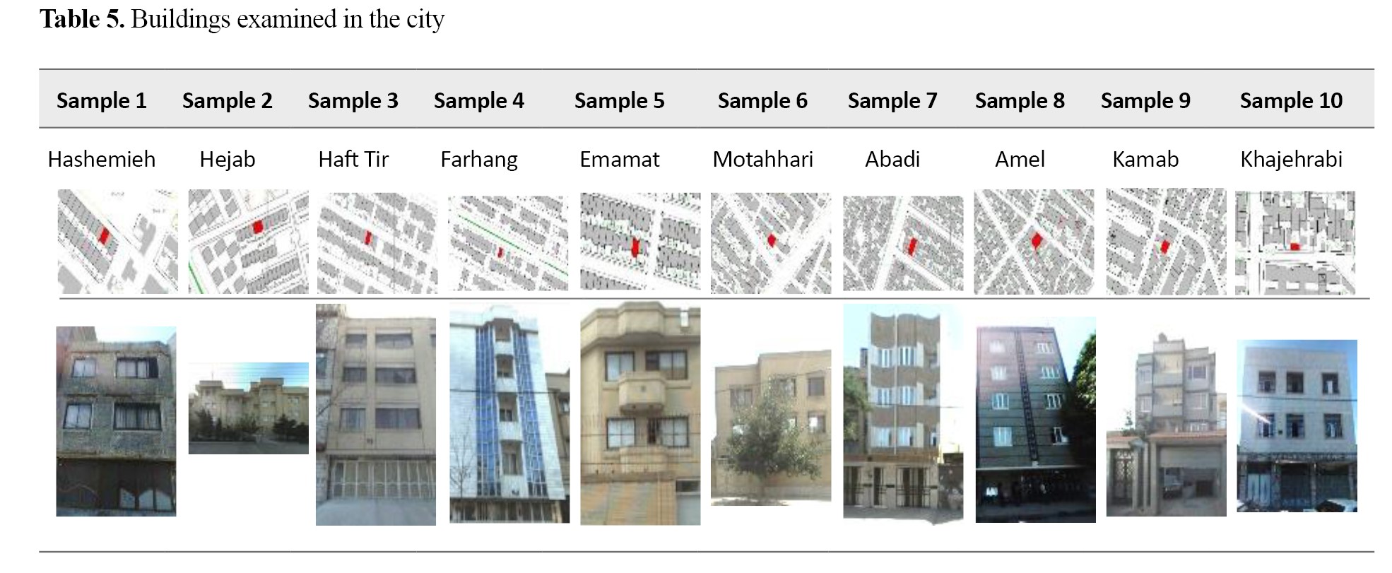
The sample buildings were selected from among the common residential apartments in Mashhad City for the middle social class. The selected plots ranged from 150 to 300 square meters, and the number of floors ranged from 3 to 6. In total, 51 residential units from 10 buildings, with a population of 109 individuals and 51 families, were selected, with a gender ratio of 53.56 (female to male).
Table 5 presents the site map and a photo of the main facade of the selected samples.
 Data analysis
Given its multidimensional nature, seismic resilience assessment requires an approach capable of both handling data complexity and reflecting the relative importance of different criteria. To achieve this objective, the present study employed a hybrid framework combining principal component analysis (PCA) and the analytic hierarchy process (AHP). This integration merges the objectivity of statistical analysis with expert judgment to achieve a comprehensive and balanced assessment (Martínez et al., 2012).
Data preprocessing
To prepare the data for analysis, preprocessing focused on Z-score normalization. The main reason for this step was the difference in the measurement scales of the variables. Standardization, by converting all variables to a dimensionless scale with a mean of zero and a standard deviation of one, prevents the possible dominance of variables with higher variance. This essential step is a necessary prerequisite for performing PCA and significantly improves the accuracy and reliability of the results (Freire-Garv. et al., 2016). In addition, the Shapiro–Wilk test was used to examine the normality of the data distribution, and the corresponding P value was calculated.
Principal component analysis
PCA was conducted to reduce data dimensionality, identify the underlying structure, and objectively determine the most influential set of variables affecting seismic resilience. The analysis was based on the correlation matrix derived from the 27 standardized variables. At the beginning of the process, the Spearman correlation coefficient was calculated for each pair of variables and assembled into a matrix. Then, the eigenvalues and eigenvectors of the covariance matrix, which can determine the direction of data dispersion, were calculated. To ensure the validity of the results, collinearity, sample adequacy, and sufficient correlation among variables were assessed using the Kaiser–Meyer–Olkin (KMO) measure and Bartlett’s test of sphericity.
To determine the optimal number of principal components, variables with eigenvalues greater than 1 were retained. In addition, a scree plot was used to identify the elbow point. The elbow point in the scree plot, representing a sharp reduction in the slope of the curve, was considered an indicator for determining the optimal number of principal components.
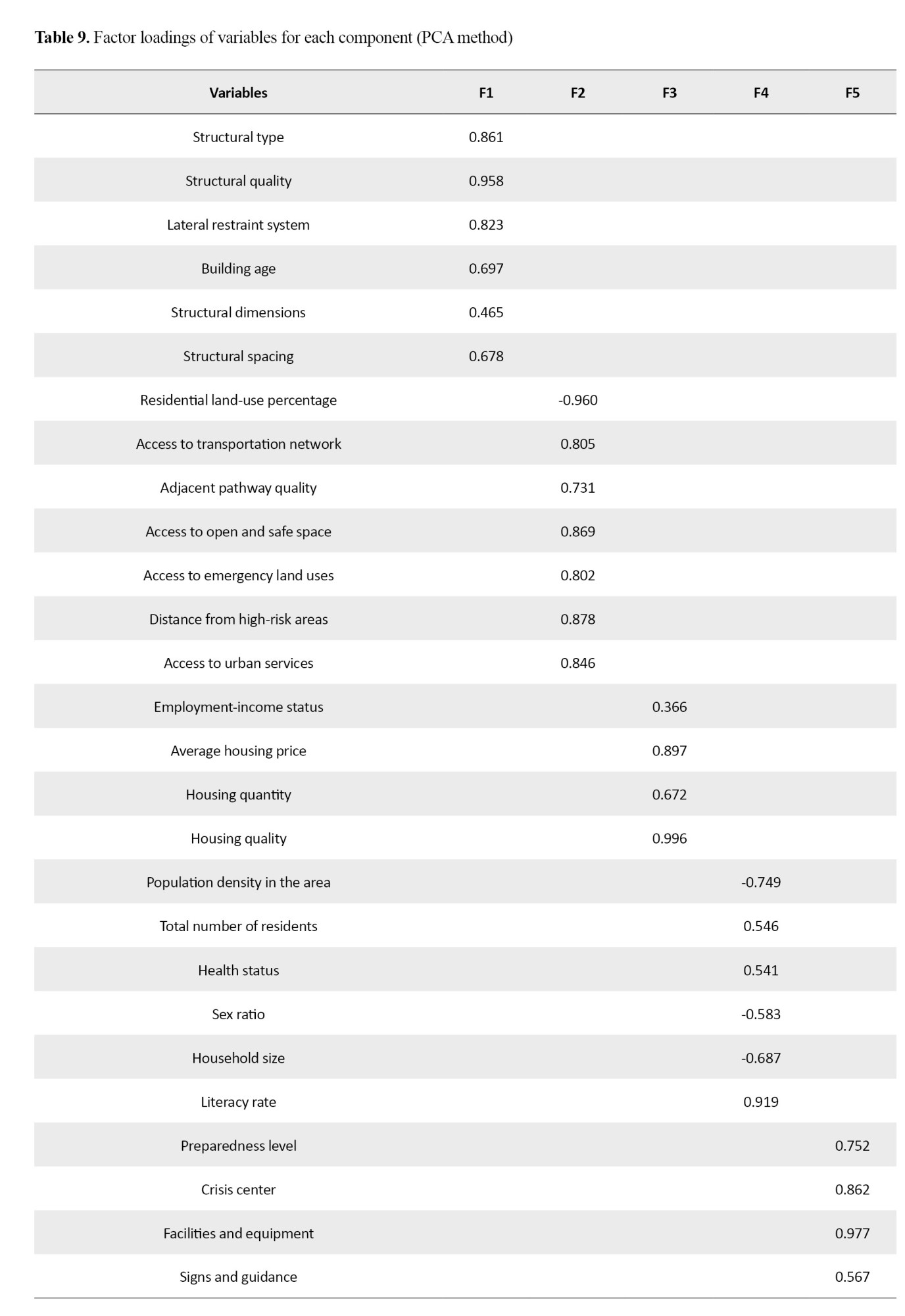
To simplify the factor structure and facilitate interpretability, varimax rotation was applied. Variables with an absolute factor loading greater than 0.6 on a component were identified as influential variables in that dimension. Variables whose loadings did not reach this threshold on any component, or that loaded simultaneously on multiple components, were removed from the final analysis. The output of PCA provided an objective reduced set of variables, which served as the basis for the hierarchical analysis structure.
Analytic hierarchy process
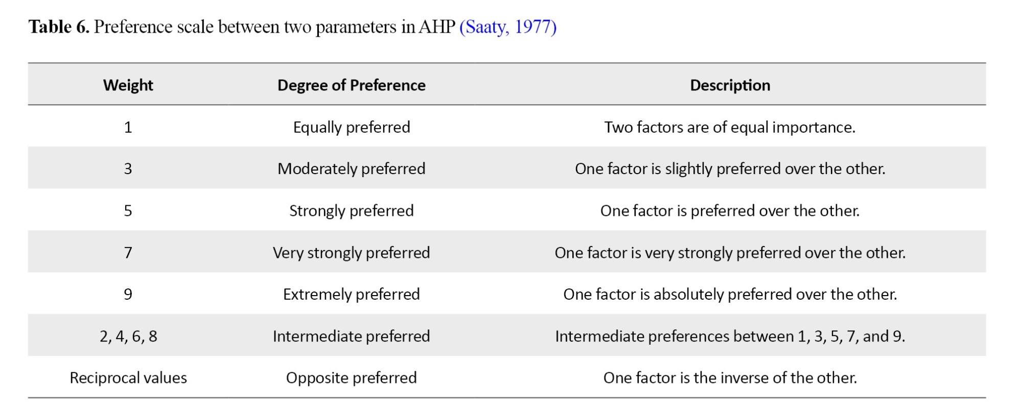
In the next step, to assign weights to the criteria and sub-criteria identified through PCA, the AHP method developed by Saaty (1977) was used. For data collection in this section, a pairwise comparison questionnaire based on Saaty’s 9-point scale (
Table 6) was designed, and 6 experts with academic and executive experience in construction, urban planning, and crisis management were asked to compare the relative importance of the main criteria extracted from PCA, as well as the sub-criteria within each criterion.
For each pairwise comparison, a comparison matrix was constructed, and the final weight of each factor was calculated using the geometric mean of expert judgments and the eigenvector method. To ensure the reliability of the judgments, the consistency ratio (CR) was calculated for each matrix. Accordingly, only matrices with a consistency ratio of less than or equal to 0.1 were considered acceptable. Otherwise, the judgments were returned to the experts for revision. The final average consistency ratio for all matrices was 0.06, indicating consistent and reliable judgments.
Integration of principal component analysis and analytic hierarchy process results
The final output of this hybrid process was the determination of a final weight for each resilience indicator. These weights were calculated by multiplying the weight of each indicator at its level in the hierarchical structure by the weight of the corresponding upper-level criterion (the principal component in which the indicator was placed). These integrated weights simultaneously reflect both the intrinsic importance of each indicator based on expert judgment and its role within the overall resilience structure based on data analysis. Ultimately, these weights formed the basis for calculating the resilience score for each residential apartment examined in Mashhad City.
Results
Descriptive statistics and normality assessment
The data in this study comprised 27 quantitative variables under five criteria: physical, infrastructural, economic, social, and managerial, which were collected for the samples. Prior to conducting multivariate analyses, the normality of the data distribution was examined using the Shapiro–Wilk test. The results showed that most variables (23 variables) did not meet the assumption of normality (P<0.05). Accordingly, nonparametric methods, particularly the Spearman correlation coefficient and factor analysis based on the Spearman correlation matrix, were used for subsequent analyses.
Assessment of data adequacy and significance of correlations
Before extracting the principal components, the prerequisites for factor analysis were evaluated using the KMO measure and Bartlett’s test. The K KMO value, which assesses sampling adequacy, was 0.842, exceeding the acceptable threshold of 0.7 and indicating a high level of data adequacy for factor analysis. Bartlett’s test, used to assess the overall significance of the correlation matrix, yielded an approximate chi-square value of 2187.34 with a significance level of P<0.001, leading to the rejection of the null hypothesis (that the correlation matrix is identical to the identity matrix). This result indicates sufficient and significant correlations among the variables for factor analysis.
Analysis of the Spearman correlation matrix
Examination of the Spearman correlation matrix presented in
Table 7 revealed significant patterns among the variables.
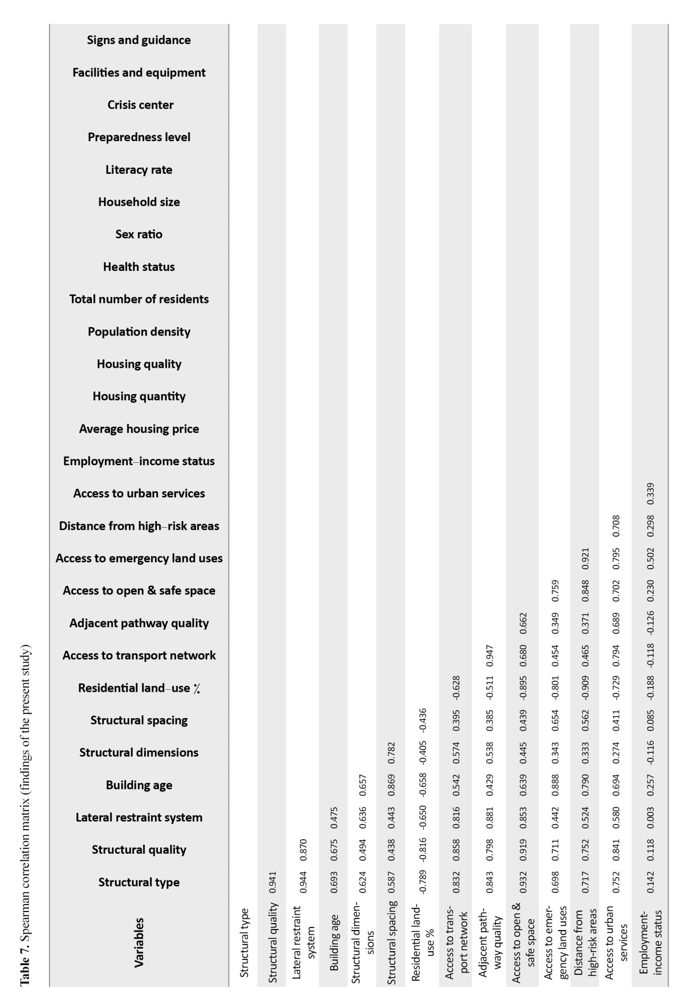
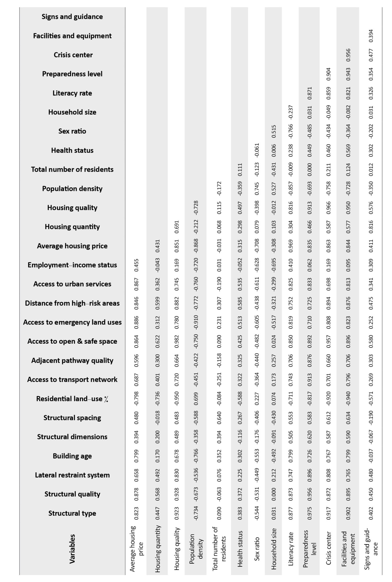
In summary, the strongest significant positive correlations (P<0.01, rs >0.7) were observed among the variables related to the physical component. In addition, notable positive correlations were found between housing quality, literacy rate, and essential facilities and equipment with other variables. On the other hand, significant negative correlations were identified between the percentage of residential land use in the infrastructural component and other variables (P<0.05, rs ≈ −0.65). These findings preliminarily confirm the presence of latent dimensions and an underlying structure in the data.
Principal component extraction
To reduce data dimensionality, PCA was employed using Varimax rotation, guided by two criteria: eigenvalues greater than 1 and the scree plot. The scree plot (
Figure 3) shows a clear break (elbow point) after the fifth component, confirming the extraction of five principal components.
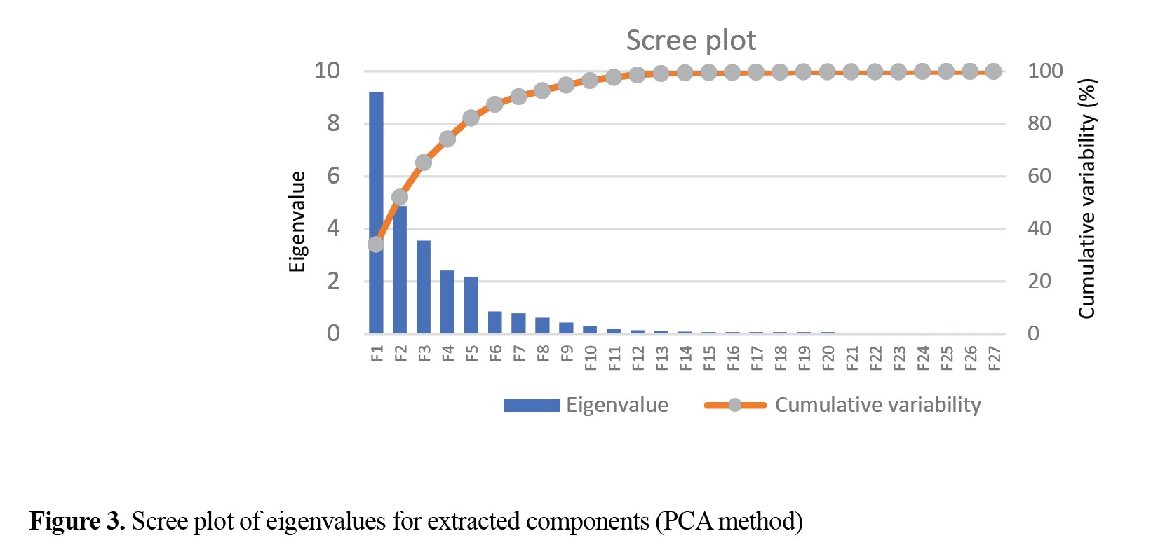
Ultimately, five principal components were extracted, which collectively explain 82.32% of the total data variance.
Table 8 presents the variance explained by each component.
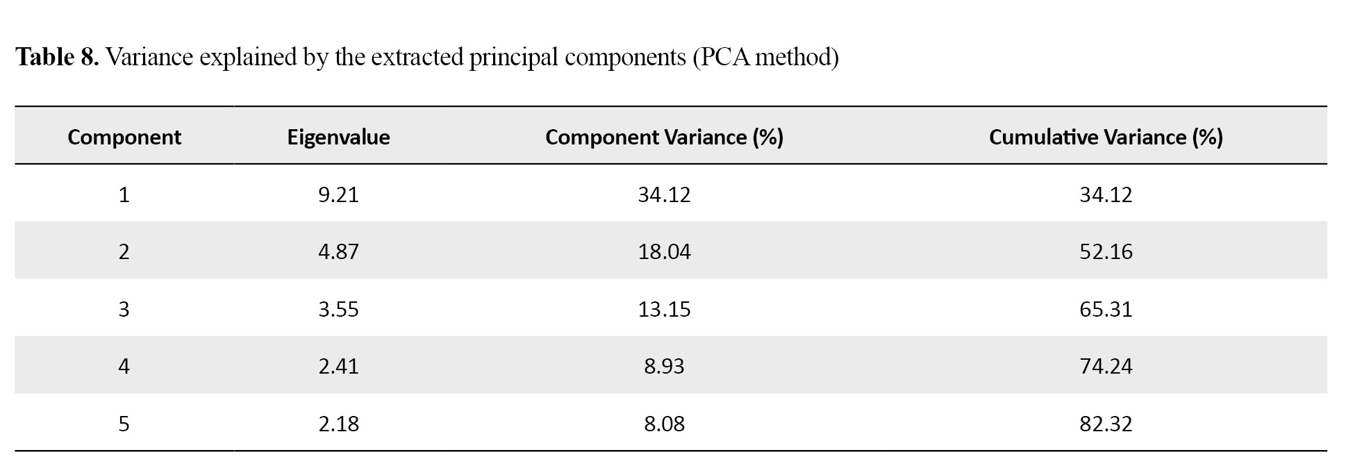
Following the initial component extraction, Varimax rotation was utilized to simplify their interpretation. This rotation aims to maximize the variance between factors, ensuring that each variable exhibits a high factor loading on only one factor. This process facilitates easier labeling and interpretation of the factors.
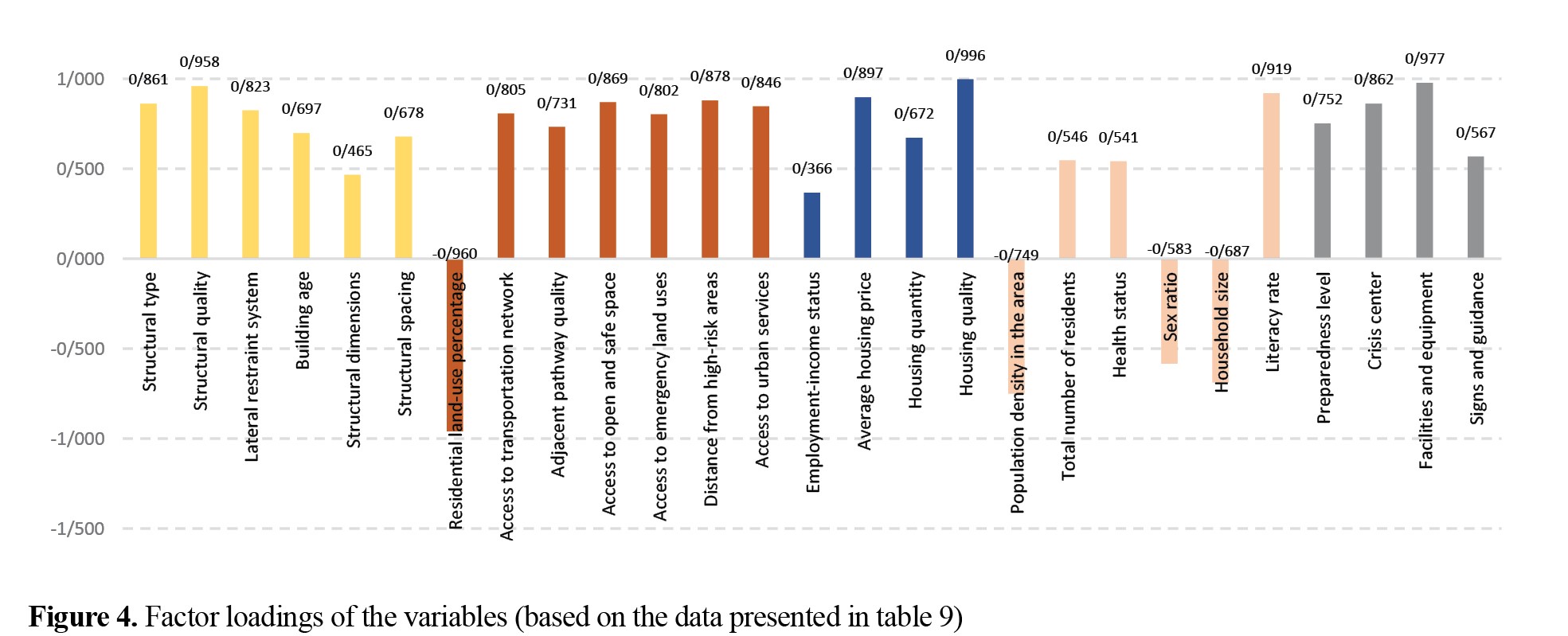
Table 9 and
Figure 4 present the factor loadings of the variables following Varimax rotation, indicating the component to which each variable belongs.
Determination of criterion weights
To assign weights to the criteria and integrate them into a final composite index, the AHP was employed. The data required for this method were collected through a pairwise-comparison questionnaire based on experts’ opinions. After the questionnaires were collected, a pairwise-comparison matrix was constructed for each expert, and the weight of each criterion and its corresponding consistency ratio were calculated. The geometric mean of the opinions of all experts was considered the final pairwise comparison. The weights of the criteria, subcriteria, and the final consistency ratio were calculated, and the results are presented in
Table 10.
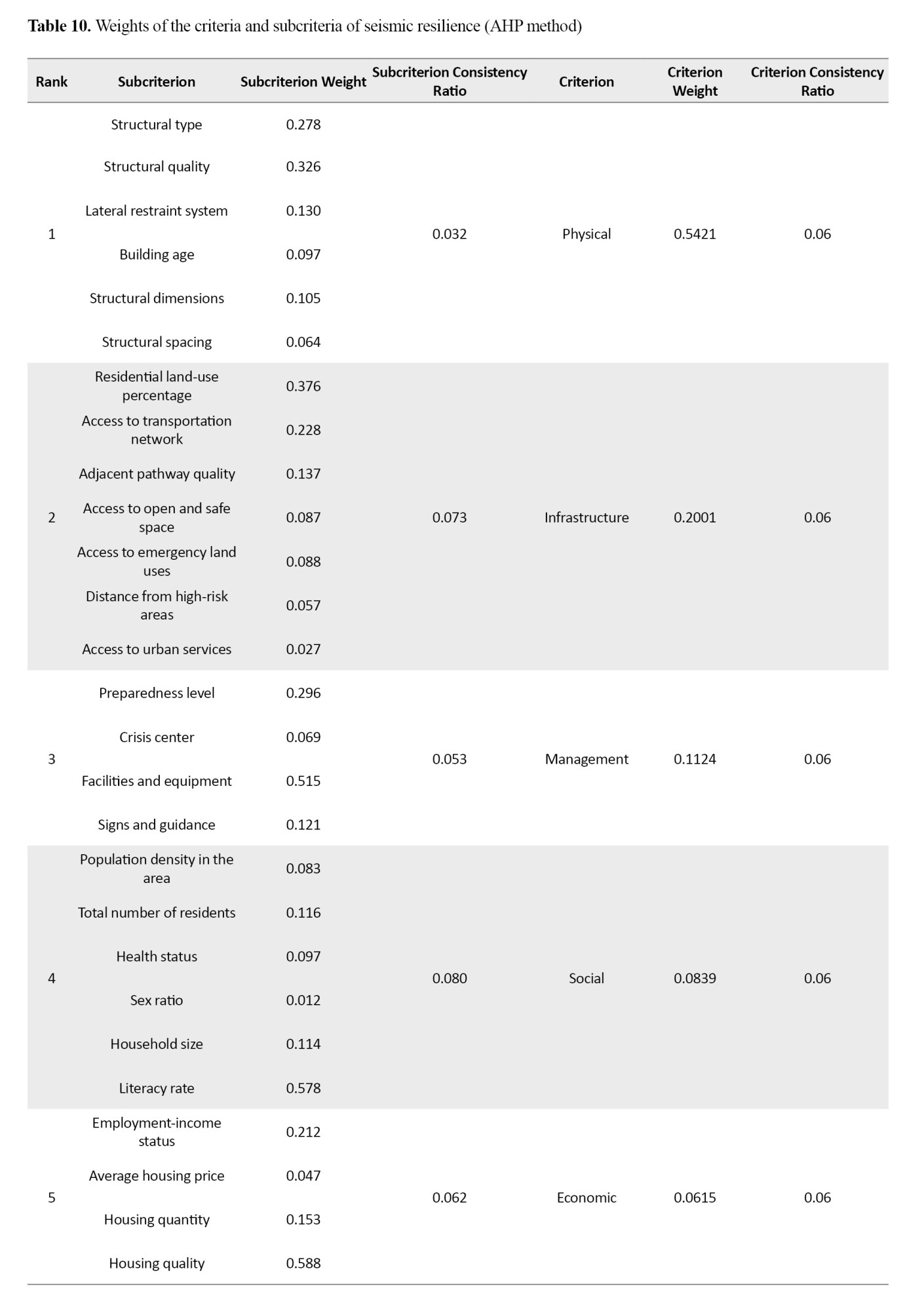
As shown, the final CR value was 0.06, which is lower than 0.1 and indicates the high reliability and consistency in the experts’ judgments.
Based on a comprehensive analysis of the collected data and the results obtained from the multicriteria assessment of seismic-resilience indicators,
Figures 5 and
6 show the conditions of the ten selected residential buildings in Mashhad City.
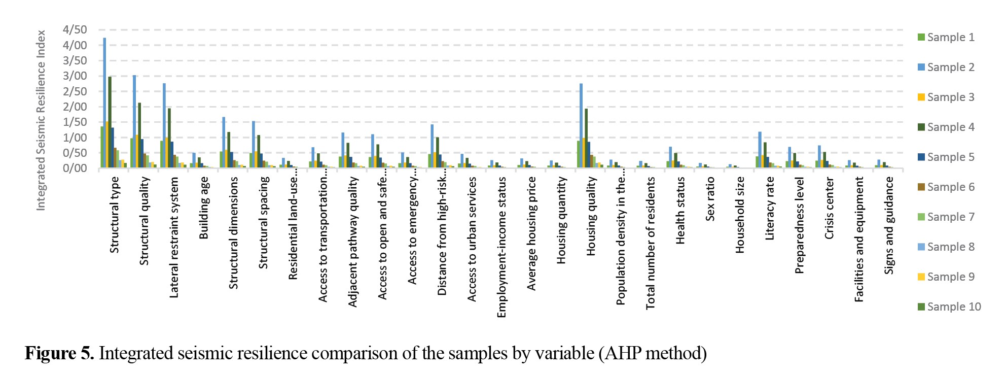
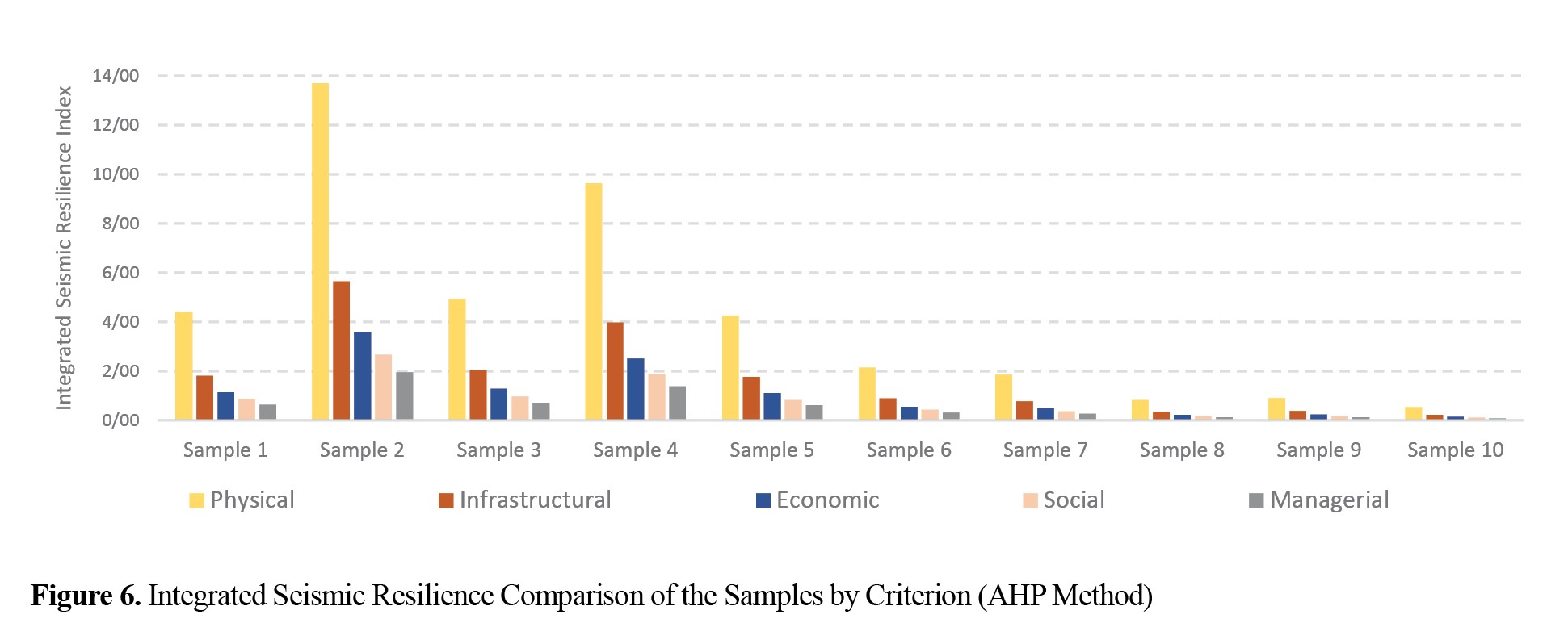
The findings indicate that Sample 2 achieved the highest scores for most of the evaluated variables and was identified as the most resilient building among the examined samples. In contrast, Sample 10 received the lowest scores for most indicators and was assessed as the most vulnerable building to earthquake hazards. Buildings in the central and old urban fabric generally demonstrated the lowest resilience compared with those in other areas. In contrast, buildings in the new urban fabric of Mashhad City were in considerably better condition in terms of seismic resilience and exhibited greater resilience to the effects of earthquakes.
Discussion
Assessment of seismic resilience from a physical perspective
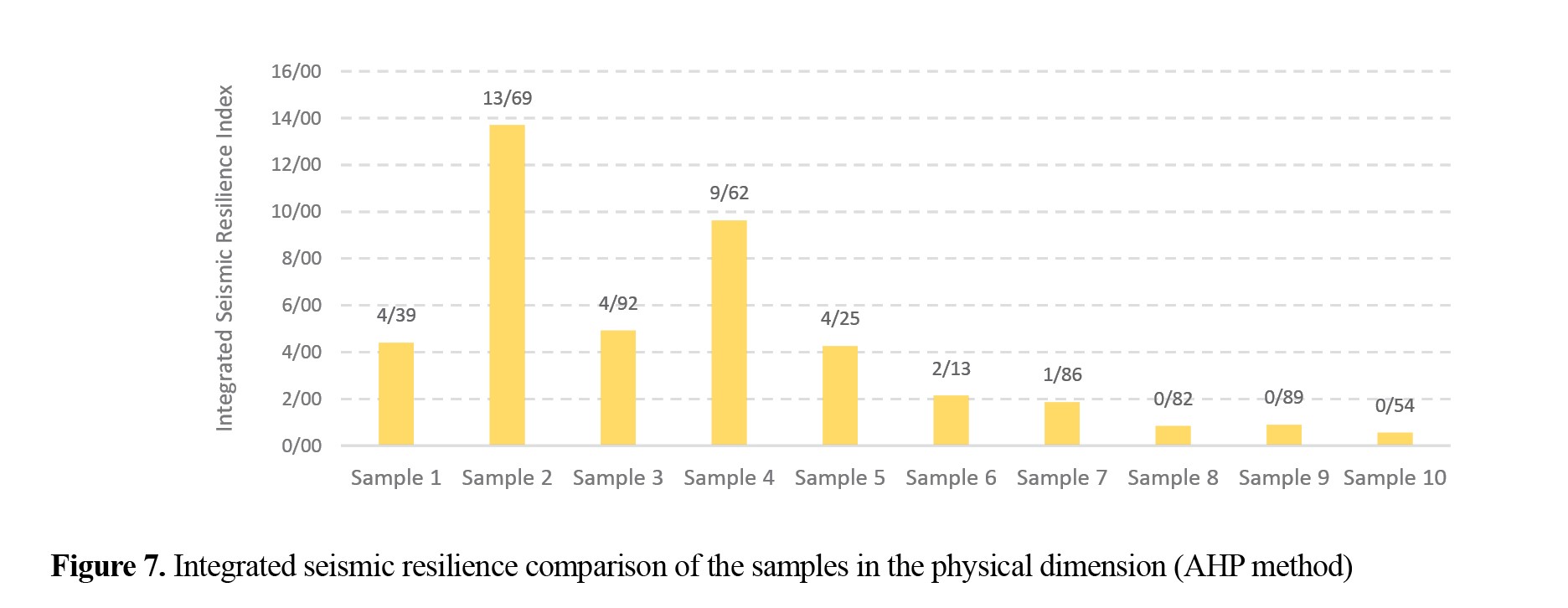
Several variables can represent physical resilience; however, in the present study, the variables that had received the greatest emphasis in the literature and also met the requirements of precise measurement and accessibility—namely, structural type, structural quality, lateral restraint system, building age, structural dimensions, and structural spacing—were examined. Among these, structural type, structural quality, and the lateral restraint system play a more important role in ensuring seismic resilience and are the most relevant predictors. A strong correlation is observed between seismic resilience and these variables, although it sometimes leads to inaccurate conclusions.
Although apartments with more than four floors accommodate more people and have higher asset value, their construction methods, quality, and materials generally reduce the risk of collapse and increase resilience. Buildings with lower resilience are, for the most part, low-rise and located in the city’s old urban fabric (
Figure 7).
Assessment of seismic resilience from an infrastructural perspective
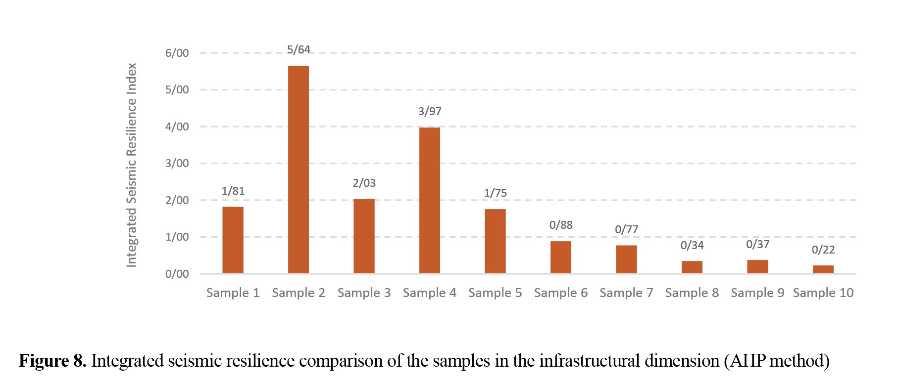
The variables examined in the present study to assess infrastructural resilience include the percentage of residential land-use coverage within the surroundings of the building under study, the accessibility conditions of the building to the transportation network and main pathways, the quality of the adjacent pathway under hazardous conditions, access to open and safe space, access to emergency land uses (medical, firefighting, and police services), distance from hazardous zones, locations, and land uses, and access to urban services (water, electricity, gas, telephone, internet, etc.).
The high density of urban buildings reduces resilience, as it can create obstacles in the event of seismic damage. In central urban areas, building collapse can block access to the area, whereas in newer areas—which have a higher proportion of open spaces and lower housing density—resilience is increased (
Figure 8).
Moreover, distance from emergency and service centers, ease of circulation, and distance from hazardous locations are significantly associated with survival probability and enhanced resilience.
Assessment of seismic resilience from an economic perspective
Seismic resilience conditions from an economic perspective were evaluated based on employment–income status, average housing price, housing quantity, and housing quality, among which housing quality exerted the greatest influence on seismic resilience.
Figure 9 shows the condition of the examined samples from this perspective.
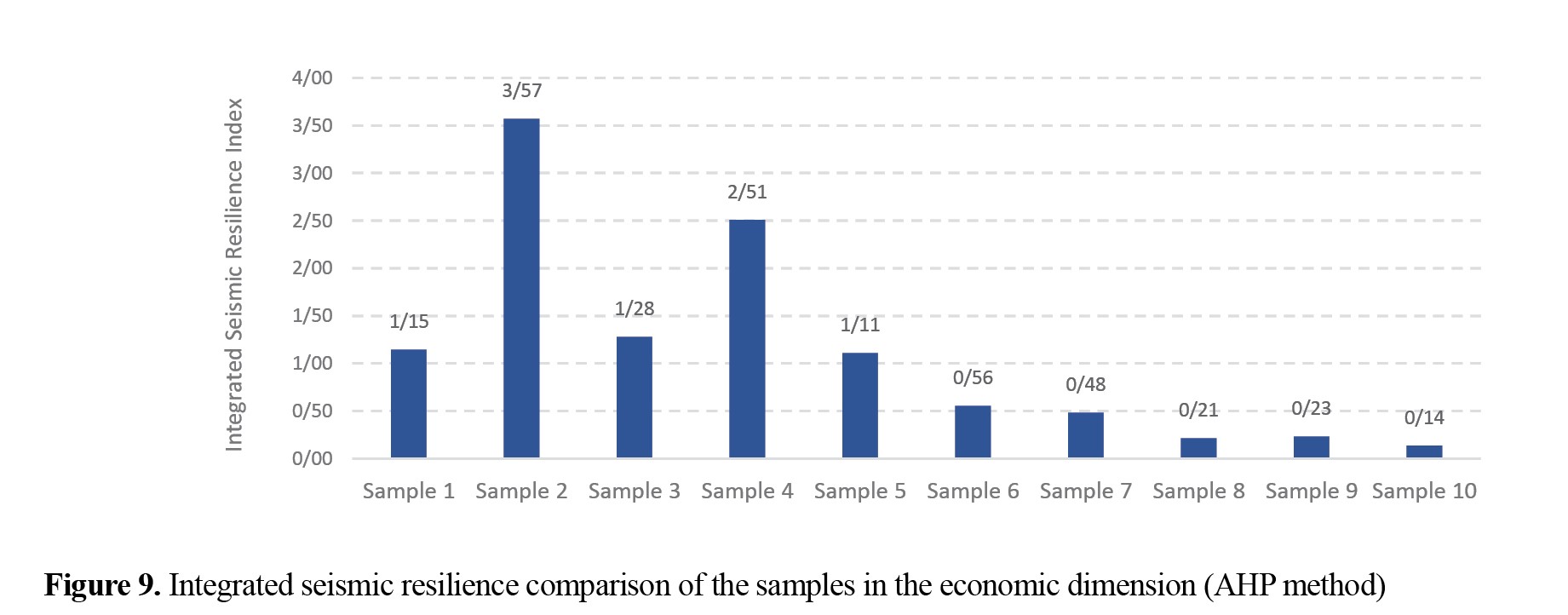
Evaluating the data trends for economic variables across the ten examined samples indicates that the housing quality parameter serves as a highly decisive indicator of resilience from an economic perspective.
Assessment of seismic resilience from a social perspective
The population exposed to earthquakes is the most critical variable to consider when assessing seismic resilience. To evaluate seismic resilience from a social perspective, population density in the area, total number of residents, physical health status (average age), sex ratio, household size, and literacy rate were examined. Among these, the literacy rate played a more prominent role in ensuring seismic resilience.
Figure 10 shows the conditions of the examined samples from a social perspective.
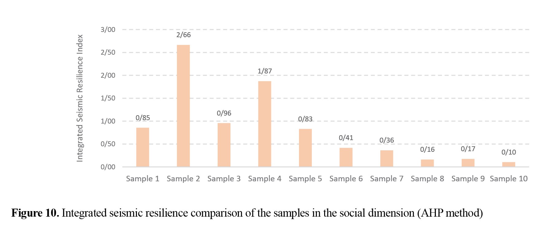
In addition to the literacy rate variable, individuals’ health status is also closely associated with ensuring resilience conditions. Accordingly, it can be concluded that variables fostering resilience in the social dimension share substantial common ground with the quality of social life as well as cultural and educational components of society.
Assessment of seismic resilience from a managerial perspective
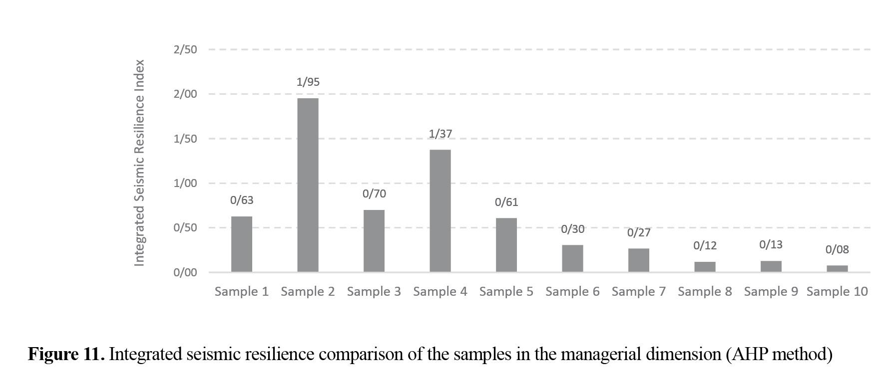
Managerial variables influencing seismic resilience are highly complex and multifaceted; however, they can generally be examined across two stages: pre-earthquake and post-earthquake measures. In this study, the level of urban management preparedness in the event of an earthquake, the presence of multipurpose and crisis centers within the catchment radius of the examined samples, essential facilities and equipment anticipated prior to a crisis, and the installation of appropriate signs and guidance for emergency access were among the evaluated variables against which the conditions of the examined samples could be compared (
Figure 11).
Principal components of seismic resilience
The PCA results indicate significant correlations between the studied variables and the level of seismic resilience in buildings. Based on this analysis, the physical component, as one of the most critical principal components, exerts the greatest impact on determining the level of seismic resilience. Meanwhile, given the direct relationship between the evaluated parameters and the resilience indicators, it can be asserted that housing quality—with a factor loading of 0.99-is the most critical parameter.
Conclusion
By presenting an integrated, quantitative framework, this research has transformed seismic resilience from a theoretical concept into an operational and measurable scale for Mashhad City. The findings clearly demonstrate that investment solely in engineering, without simultaneous attention to social and managerial components, is not a comprehensive strategy for increasing resilience. The model presented in this study is not only a powerful tool for urban planners and crisis managers in Mashhad City but can also be utilized as a methodological model for other Iranian metropolises facing similar challenges. Implementing the proposed solutions based on scientific prioritization can significantly increase the seismic resilience of the Mashhad metropolis and prevent a natural event from turning into a widespread human catastrophe.
Quantitative analyses using a combination of AHP and PCA showed that physical and infrastructural indices accounts for 74.22% of total resilience, making them for more prominent than other dimensions. Among the variables affecting resilience, housing quality (factor loading 0.996), essential facilities and equipment (factor loading 0.977), residential land-use percentage (factor loading -0.960), structural quality (factor loading 0.958), and literacy rate (factor loading 0.919) have the greatest impact on the calculation of integrated resilience. On the other hand, although socio-economic indices with a cumulative weight of 14.54% have a smaller share in ensuring resilience, the factor loadings of the housing quality (0.996) and literacy rate (0.919) variables indicate that the concentration of low-income and low-literacy populations, especially in deteriorated urban fabrics, is a critical risk-intensifying point; consequently, in these neighborhoods, the resilience index in the social dimension is at its lowest compared to other parts of the city.
Given the obtained quantitative findings, strategies for improving urban resilience are categorized and presented in three priorities: short-term, medium-term, and long-term. The first priority, which has a short-term nature and involves physical-managerial interventions, focuses on implementing emergency programs, technical audits, and retrofitting buildings, especially in areas with a construction quality index lower than 0.5. Supplying and equipping urban spaces with essential facilities and removing physical barriers to accessing these spaces are also considered vital measures. In the second priority, with a medium-term approach based on capacity building in the infrastructural sector, creating and increasing the per capita open space in areas identified as high-risk centers with very low resilience should be on the agenda. In parallel, developing an integrated building information system for continuous monitoring and updating of physical indices is essential. Finally, the third priority, with a long-term horizon focused on social empowerment, emphasizes implementing targeted educational programs for residents of high-risk neighborhoods with crisis response content, tailored to the socio-economic characteristics of the local community. Improving citizens’ literacy and awareness is also considered an integral part of this long-term priority.
Limitations
In this research, to focus on the functional comparison of the options under study within Mashhad’s urban fabric, climatic and geographic parameters, as well as earthquake occurrence scenarios, were considered identical for all options. However, climatic conditions, geographic location, and the intensity of potential earthquakes can potentially exert different effects on the seismic resilience of each option. Additionally, the cybersecurity and information security variable, especially in the managerial sector, is recognized as an influential and determining factor. Nevertheless, due to existing limitations in accessing reliable sources and sufficient data, this variable was not accurately evaluated in the research. It is recommended that future research address and investigate this aspect.
Furthermore, despite utilizing PCA as an objective basis for initial weighting, the judgment and evaluation phase in the AHP has a subjective nature. To reduce this inherent limitation, the consistency ratio control criterion was strictly and precisely applied. Moreover, significant efforts were made to utilize the opinions and expertise of experienced experts in this field. However, reaching a complete consensus in all pairwise comparisons was a difficult and challenging task. To mitigate this challenge, the geometric mean of expert opinions was employed, which helped alleviate this limitation to some extent.
Finally, it should be noted that the generalizability of this research’s findings is limited to Mashhad’s urban fabric, and the weights obtained are specific to this region. Therefore, to use these results in other cities, the localization process must be carried out separately, proportional to the specific conditions and characteristics of each city.
Ethical Considerations
Compliance with ethical guidelines
In this study, all ethical principles were observed. No experiments on human or animal samples were conducted. Therefore, no ethical approval code was needed.
Funding
This research did not receive any specific grant from funding agencies in the public, commercial, or not-for-profit sectors.
Authors' contributions
Conceptualization, methodology, investigation, funding acquisition and writing: Ehsan Biglari and Ali Biglari; Supervision: Ali Biglari.
Conflicts of interest
The authors declared no conflict of interest.
References
Adger, W. N. (2000). Social and ecological resilience: Are they related? Progress in Human Geography, 24(3), 347-364. [DOI:10.1191/030913200701540465]
Adger, W. N., Hughes, T. P., Folke, C., Carpenter, S. R., & Rockström, J. (2005). Social-Ecological Resilience to Coastal Disasters. Science, 309(5737), 1036-1039. [DOI:10.1126/science.1112122] [PMID]
Alberti, M. (2005). The Effects of Urban Patterns on Ecosystem Function. International Regional Science Review, 28(2), 168-192. [DOI:10.1177/0160017605275160]
Allami, M., Biglari, E., & Biglari Fadafan, A. (2024). [Solutions to Optimize Energy Consumption in the Architecture of Cold Climate Regions (Persian)]. Iranian Journal of Energy, 27(1), 25-46. [Link]
Amanpour, S., Mohammadi Deh Cheshme, M., & Alizadeh, M. (2016). [Evaluating vulnerability of kuhdasht urban infrastructure's through passive defense approach (Persian)]. Town and Country Planning, 8(1), 133-154. [DOI:10.22059/jtcp.2016.59145]
Anwar, G. A., Dong, Y., & Li, Y. (2020). Performance-based decision-making of buildings under seismic hazard considering long-term loss, sustainability, and resilience. Structure and Infrastructure Engineering, 17(4), 454-470. [DOI:10.1080/15732479.2020.1845751]
Armas, I., Ionescu, R., & Posner, C. N. (2015). Flood risk perception along the Lower Danube river, Romania. Natural Hazards, 79(3), 1913-1931. [DOI:10.1007/s11069-015-1939-8]
Aslani, F., Amini Hosseini, K., & Fallahi, A. (2019). Evaluation of physical resilience of Karaj city against earthquake. Quarterly Scientific Journal of Rescue and Relief, 11(1), 68-71. [DOI:10.52547/jorar.11.1.68]
Aslani, F., & Amini Hosseini, K. (2018). [An overview to the concepts, indicators, frames and models of earthquake resilience (Persian)]. Disaster Prevention and Management Knowledge (quarterly), 8(2), 119-136. [Link]
Bocchini, P., Frangopol, D. M., Ummenhofer, T., & Zinke, T. (2013). Resilience and Sustainability of Civil Infrastructure: Toward a Unified Approach. Journal of Infrastructure Systems, 20(2), 04014004. [DOI:10.1061/(ASCE)IS.1943-555X.0000177]
Boon, H. J., Cottrell, A., King, D., Stevenson, R. B., & Millar, J. (2012). Bronfenbrenners bioecological theory for modelling community resilience to natural disasters. Natural Hazards, 60(2), 381-408. [DOI:10.1007/s11069-011-0021-4]
Bruneau, M., Chang, S. E., Eguchi, R. T., Lee, G. C., O’Rourke, T. D., & Reinhorn, A. M., et al. (2003). A Framework to Quantitatively Assess and Enhance the Seismic Resilience of Communities. Earthquake Spectra, 19(4), 733-752. [DOI:10.1193/1.1623497]
Bruneau, M., & Reinhorn, A. (2007). Exploring the Concept of Seismic Resilience for Acute Care Facilities. Earthquake Spectra, 23(1), 41-62. [DOI:10.1193/1.2431396]
Burton, H. V., Deierlein, G., Lallemant, D., & Lin, T. (2015). Framework for Incorporating Probabilistic Building Performance in the Assessment of Community Seismic Resilience. Journal of Structural Engineering, 142(8), C4015007. [DOI:10.1061/(ASCE)ST.1943-541X.0001321]
Carreño, M. L., Cardona, O. D., & Barbat, A. H. (2007). Urban seismic risk evaluation: A holistic approach. Natural Hazards, 40(1), 137-172. [DOI:10.1007/s11069-006-0008-8]
Chee Yin, H., Kassem, M. M., & Mohamed Nazri, F. (2022). Comprehensive Review of Community Seismic Resilience: Concept, Frameworks, and Case Studies. Advances in Civil Engineering, 2022(1), 7668214. [DOI:10.1155/2022/7668214]
Cimellaro, G. P., Reinhorn, A. M., & Bruneau, M. (2010). Framework for analytical quantification of disaster resilience. Engineering Structures, 32(11), 3639-3649. [DOI:10.1016/j.engstruct.2010.08.008]
Cutter, S. L., Boruff, B. J., & Shirley, W. L. (2003). Social Vulnerability to Environmental Hazards. Social Science Quarterly, 84(2), 242-261. [DOI:10.1111/1540-6237.8402002]
De Risi, R., Bhattacharya, S., & Goda, K. (2018). Seismic performance assessment of monopile-supported offshore wind turbines using unscaled natural earthquake records. Soil Dynamics and Earthquake Engineering, 109, 154-172. [DOI:10.1016/j.soildyn.2018.03.015]
Dodanwala, T. C., & Ruparathna, R. (2024). Ensuring the resilience of multi-unit residential buildings (MURBs): A building information modeling (BIM)-based evaluation approach. Sustainable and Resilient Infrastructure, 9(5), 421-443. [DOI:10.1080/23789689.2024.2325261]
El-Maissi, A. M., Argyroudis, S. A., Kassem, M. M., Leong, L. V., & Mohamed Nazri, F. (2022). An Integrated Framework for the Quantification of Road Network Seismic Vulnerability and Accessibility to Critical Services. Sustainability, 14(19), 12474. [DOI:10.3390/su141912474]
Elo, S., & Kyngäs, H. (2008). The qualitative content analysis process. Journal of Advanced Nursing, 62(1), 107-115. [DOI:10.1111/j.1365-2648.2007.04569.x] [PMID]
Frigerio, I., Ventura, S., Strigaro, D., Mattavelli, M., De Amicis, M., & Mugnano, S., et al. (2016). A GIS-based approach to identify the spatial variability of social vulnerability to seismic hazard in Italy. Applied Geography, 74, 12-22. [DOI:10.1016/j.apgeog.2016.06.014]
Hayati, S., Ghorbani, A., Esmaeili, A., & Ghanbari, M. (2015). [Studying the vulnerability of Iranian cities during earthquakes (example: Mashhad city) (Persian). Paper presented at International Conference on Civil Engineering, Architecture and Urban Infrastructure. [Link]
Hung, H. C., Lin, Y. C., Hung, C. H., & Chen, B. H. (2024). Enhancing resilience in ageing: The role of age-friendly community and individual health in reducing seismic risk. International Journal of Disaster Risk Reduction, 111, 104733. [DOI:10.1016/j.ijdrr.2024.104733]
Kärrholm, M., Nylund, K., & Prieto de la Fuente, P. (2014). Spatial resilience and urban planning: Addressing the interdependence of urban retail areas. Cities, 36(36), 121-130. [DOI:10.1016/j.cities.2012.10.012]
Kilanitis, I., & Sextos, A. (2019). Integrated seismic risk and resilience assessment of roadway networks in earthquake prone areas. Bulletin of Earthquake Engineering, 17(1), 181-210. [DOI:10.1007/s10518-018-0457-y]
Kim, K., Luna-Navarro, A., Ciurlanti, J., & Bianchi, S. (2024). A multi-criteria decision support framework for designing seismic and thermal resilient facades. Architecture, Structures and Construction, 4, 195-210. [DOI:10.1007/s44150-024-00116-0]
Klein, R. J. T., Nicholls, R. J., & Thomalla, F. (2003). Resilience to natural hazards: How useful is this concept? Global Environmental Change Part B: Environmental Hazards, 5(1), 35-45. [DOI:10.1016/j.hazards.2004.02.001]
Maroufi, H., & Borhani, M. (2022). A measurement of community seismic resilience in sub-city districts of Mashhad, Iran. Journal of Environmental Planning and Management, 65(4), 675-702. [DOI:10.1080/09640568.2021.1902790]
Martins, V. N., e Silva, D. S., & Cabral, P. (2012). Social vulnerability assessment to seismic risk using multicriteria analysis: The case study of Vila Franca do Campo (São Miguel Island, Azores, Portugal). Natural Hazards, 62(2), 385-404. [DOI:10.1007/s11069-012-0084-x]
Mitchell, T., & Harris, K. (2012). Resilience: A risk management approach. London: Overseas Development Institute. [Link]
Moghaddas, N., Leo, C., Rahimi, B., & Azadi, A. (2018). Morpho-tectonics and Geoelectrical method applied to active faults characterization in South of Mashhad Plain, Northeast of Iran. Geopersia, 8(1), 13-26. [DOI:10.22059/geope.2017.230489.648312]
Niazi, M., Raissi Dehkordi, M., Eghbali, M., & Samadian, D. (2021). Seismic resilience index evaluation for healthcare facilities: A case study of hospital in Tehran. International Journal of Disaster Risk Reduction, 65, 102639. [DOI:10.1016/j.ijdrr.2021.102639]
Oiște, A. M., & Breabăn, I. G. (2012). Analysis of relief Iasi city and urban environment quality, using GIS techniques. Lucrări Ştiinţifice, 55, 243-248. [Link]
Osborne, J. W., & Overbay, A. (2004). The power of outliers (and why researchers should ALWAYS check for them). Practical Assessment, Research, and Evaluation, 9(6), 6. [DOI:10.7275/qf69-7k43]
Peyravi, H., Razavi Nejad, M., Ghanbari, M., Jajromi, H., Emami, M., & Parsae, M., et al. (2020). [Atlas of neighborhoods of Mashhad city (Persian)]. Mashhad: Boye-Shahre-Behesht. [Link]
Pitilakis, K., Argyroudis, S., Kakderi, K., & Selva, J. (2016). Systemic Vulnerability and Risk Assessment of Transportation Systems Under Natural Hazards Towards More Resilient and Robust Infrastructures. Transportation Research Procedia, 14, 1335-1344. [DOI:10.1016/j.trpro.2016.05.206]
Proag, V. (2014). The Concept of Vulnerability and Resilience. Procedia Economics and Finance, 18, 369-376. [DOI:10.1016/S2212-5671(14)00952-6]
Rashed, T., & Weeks, J. (2003). Assessing vulnerability to earthquake hazards through spatial multicriteria analysis of urban areas. International Journal of Geographical Information Science, 17(6), 547-576. [DOI:10.1080/1365881031000114071]
Rufat, S., Tate, E., Burton, C. G., & Maroof, A. S. (2015). Social vulnerability to floods: Review of case studies and implications for measurement. International Journal of Disaster Risk Reduction, 14(4), 470-486. [DOI:10.1016/j.ijdrr.2015.09.013]
Saaty, T. L. (1977). A scaling method for priorities in hierarchical structures. Journal of Mathematical Psychology, 15(3), 234-281. [DOI:10.1016/0022-2496(77)90033-5]
Shad, R., Etemadfard, H., & Ghaemi, M. (2019). [Spatial assessment of high-rise buildings in Mashhad city using multi-scale 3D modeling in GIS (Persian)]. Paper presented at: The 5National Conference of Modern Construction Technologies High Rise Building, Mashhad, Iran, 7 March, 2019. [Link]
Sharifi, A., & Yamagata, Y. (2016). Principles and criteria for assessing urban energy resilience: A literature review. Renewable and Sustainable Energy Reviews, 60, 1654-1677. [DOI:10.1016/j.rser.2016.03.028]
Sinha, N., Priyanka, N., & Joshi, P. K. (2016). Using Spatial Multi-Criteria Analysis and Ranking Tool (SMART) in earthquake risk assessment: A case study of Delhi region, India. Geomatics, Natural Hazards and Risk, 7(2), 680-701. [DOI:10.1080/19475705.2014.945100]
Sutley, E. J., van de Lindt, J. W., & Peek, L. (2017). Community-Level Framework for Seismic Resilience. I: Coupling Socioeconomic Characteristics and Engineering Building Systems. Natural Hazards Review, 18(3), 04016014. [DOI:10.1061/(ASCE)NH.1527-6996.0000239]
Tasmen, T., Sen, M. K., Hossain, N. U. I., & Kabir, G. (2023). Modelling and assessing seismic resilience of critical housing infrastructure system by using dynamic Bayesian approach. Journal of Cleaner Production, 428, 139349. [DOI:10.1016/j.jclepro.2023.139349]
Walker, B. B., Taylor-Noonan, C., Tabbernor, A., McKinnon, T. B., Bal, H., & Bradley, D., et al. (2014). A multi-criteria evaluation model of earthquake vulnerability in Victoria, British Columbia. Natural Hazards, 74(2), 1209-1222. [DOI:10.1007/s11069-014-1240-2]
Zhao, Y., Yang, X., Zhai, C., & Wen, W. (2023). Exploring relationships of urban seismic resilience assessment indicators with a fuzzy total interpretive structural model method. Engineering, Construction and Architectural Management, 30(8), 3509-3538. [DOI:10.1108/ECAM-09-2021-0806]