Introduction
In recent decades, with the increase in the frequency and intensity of natural disasters and human-made crises, the need for effective planning and preparedness for crisis management at the urban level has gained growing importance (Azadian et al., 2022). Crisis management can be defined as a set of rules and procedures for preventing or addressing the potential risks associated with the occurrence of any natural or non-natural disaster (Wolbers & Beyorisma, 2021). In practice, crisis management comprises a range of processes that are forecast and planned before, during, and after any crisis, in order to prevent, or at least minimize as much as possible, financial and human losses. Crisis management includes four phases: prevention and mitigation, preparedness, response, and recovery (Borhani et al., 2020).
Multi-purpose spaces are one of the main components of crisis management; they are implemented to achieve various objectives ranging from prevention to confrontation, and these goals are pursued by relocating people from hazardous or damaged locations to safe areas (Basouli et al., 2021). The key components of multi-purpose spaces include providing suitable areas for the sheltering or accommodation of refugees and affected individuals, designing safe routes, issuing warnings and risk communication regarding the likelihood of hazards, planning for evacuation and return, and providing support measures, which are defined according to the scale and extent of the hazard (Abounacer et al., 2020). Urban space, within itself, accommodates infrastructure facilities and equipment associated with various land uses, including residential, administrative, educational, service, health, and others. All these categories lead to interdependent population and activities that, in the event of natural and human-made disasters, are highly affected by them and consequently cause substantial human and financial losses in cities (Christensen et al., 2019).
Hamadan, as one of the metropolises with a high population and dense urban fabric, requires efficient structures to deal with crises, such as earthquakes, floods, and unexpected events. Among the important solutions to enhance urban resilience against these threats is the use of multipurpose spaces that can play a vital role in emergency accommodation, relief, service distribution, and population management in crisis situations (Nizamido, 2022).
In Hamadan, despite the availability of infrastructure, such as sports halls, schools, and public spaces, the purposeful and organized use of these facilities as multi-purpose spaces for crisis management has not received sufficient attention so far. Meanwhile, climate change, population growth, and dense developments in some urban areas have made Hamadan a city with high vulnerability to potential crises. In this context, the absence of comprehensive assessments of the capacities and weaknesses of existing spaces has posed challenges for urban planners in making strategic decisions (Coombs & Laufer, 2019).
The necessity of this research stems from the fact that, to date, no accurate and applied evaluation of the suitability level of multi-purpose spaces in Hamadan—particularly in the crisis response phase—has been carried out. Shortcomings in the appropriate distribution of these spaces, as well as the inefficiency of some facilities, may lead in emergency conditions to reduced speed and effectiveness of rescue operations (Esmailian et al., 2021). Therefore, conducting a systematic study aimed at identifying, analyzing, and ranking urban spaces for use in critical situations is a fundamental step toward improving the performance of the urban crisis management system.
The innovation of the present study lies in that, unlike conventional approaches or theoretical studies that sometimes diverge from field realities, this research—based on spatial data, field interviews with municipal officials, and GIS map analysis—provides a clear picture of the existing strengths and weaknesses. This approach enables decision-makers to make more effective and precise decisions grounded in real, evidence-based information and logic, rather than relying on abstract models. This consideration motivated the current study to evaluate the suitability level of existing urban multi-purpose spaces in crisis management in Hamadan.
Materials and Methods
This applied descriptive–analytical study was conducted in Hamadan from 2023 to 2024 to assess the suitability level of existing urban multi-purpose spaces in crisis management in Hamadan. Initially, documentary and library-based methods were used to review the literature on the research topic, and then the city was examined. Subsequently, through field studies, a more accurate identification and analysis of the status of the indicators was performed. After collecting the required data through field methods, in accordance with the presence of key terms, such as crisis, places, and multi-purpose land uses, and the review of articles and theses with topics closely related to the present research through library research, the necessary information was compiled. In addition, by using interviews with urban authorities, such as the county (governorate) and the municipality, as well as the Department of Physical Education of Hamadan, along with field observations, the information relevant to the present study was further completed.
In the analysis phase, after classifying the information and integrating it with spatial data, spatial analysis was conducted in the GIS environment, and the results were presented as thematic maps and tables. An overall assessment of the suitability of land uses was performed separately for each area, and then—based on the status matrix of these facilities and the scores obtained by each facility—it was demonstrated which facilities fall into the categories of effective, relatively effective, or ineffective. Moreover, considering the extent of each facility and the availability of the required facilities, they were further classified into grades one, two, and three, indicating what level of performance can be expected from these spaces during a crisis.
The conceptual model was developed based on theoretical foundations and a review of previous research, and its main variable was “the suitability of multi-purpose spaces in crisis conditions”, which was evaluated based on a set of indicators, including spatial and physical–structural characteristics, such as rapid accessibility to main urban arteries, an appropriate distance from natural hazards and hazardous installations, and the topographic conditions of the terrain. In addition, service and infrastructure indicators—such as proximity to medical and emergency centers, access to supporting facilities like emergency power and health services, and the capacity and extent of the space for accommodation or multi-purpose uses—were considered. Finally, managerial and functional indicators, including the capability of organizing and managing the population, the possibility of deploying relief equipment, and the flexibility of spaces to be converted into diverse land uses, are also regarded as evaluation dimensions. Accordingly, the conceptual model showed that the suitability of multi-purpose spaces in Hamadan is influenced by three dimensions: spatial–physical, service–infrastructure, and managerial–functional. The integration and analysis of these dimensions in the GIS environment enables the achievement of accurate and reliable results (Basouli et al., 2021).
Theoretical foundations
Introduction of the study area: Hamadan County has an area of 3,521 m2 and an average elevation of 1,820 meters above sea level. It is one of the nine counties in Hamadan Province and its administrative center is the Hamadan city. The county’s population is 651,820 people, according to the 2016 census. Hamadan County comprises two districts and nine rural districts (dehestans). The county extends from the ridge line of the Alvand mountain range to the eastern boundaries of the province. Its easternmost point is located at 49°27′ and its westernmost point at 48°20′ east of the Greenwich meridian. It lies between 34°35′ and 35° north latitude.
Hamadan County is bounded to the north by Famenin, Kabudarahang, and Razan counties; to the south by Malayer, Tuyserkan, and Nahavand; to the east by Markazi Province; and to the west by Bahar and Asadabad counties. In the southern part, the Alvand mountain ranges are located, whose ridge line forms the natural boundary between Hamadan and Tuyserkan counties. The plains of Hamadan, Qahavand, Nashr plain, and a portion of the Razan–Famenin plain lie between these elevations. The highest point of Hamadan County is Mount Alvand, at an elevation of 3,584 meters, and the lowest point is the “Amirabad” lands, at 1,600 meters. The county consists of four cities—Hamadan, Maryanj, Jurqan, and Qahavand—along with two districts and nine rural districts. In Hamadan, there are 65 sports facilities (sport venues). In the present study, 50 sports halls were examined in terms of their spatial location and hall dimensions, and 12 sports halls that have public (government) ownership were evaluated according to the relevant tables.
What is a crisis?
From a realistic perspective, a crisis is defined as follows: A crisis is a set of conditions in which individuals, institutions, or societies face threats beyond their daily functioning norms, but the significance and impact of these conditions will not be in accordance with individual perceptions (Crandall et al., 2021).
Crisis management
Approaches for coping with threats are referred to by different names, such as crisis management, disaster management, or emergency management. First, it is necessary to distinguish among these three terms. In the absence of proper management, all emergency conditions have the potential to escalate and turn into a crisis. Therefore, if a crisis leads to an uncontrollable situation while the impacts resulting from this disruption cannot be contained, conditions will get out of control (Fischer et al., 2021). Since emergency management focuses on ending the threat in its early stages and on managing incident concentration in responses to threats that have escaped control, crisis management addresses threats that go beyond the capabilities of an institution and the scope of emergency response, and that have not yet been resolved (Fischer et al., 2021). The threats addressed are those that extend beyond the initial onset of emergency response and evolve into a crisis (Haaland & Wallevik, 2020). Crisis management comprises the total set of actions taken to reduce the impacts of a crisis. The standard approach to studying crisis management divides it into different stages within a crisis management cycle, consisting of four phases: prevention (threat assessment, risk analysis, mitigation strategies), preparedness (contingency planning and training), response (communications, emergency operations, and resource deployment), and recovery (reconstruction and rehabilitation) (He et al., 2020).
The calculations carried out in the prevention phase are intended to prevent a hazard from turning into a disaster or a crisis, or to reduce its adverse impacts. Due to the nature of preventive assessments, this phase is one of the most important stages of the management cycle in the face of crisis impacts. In the preparedness phase, prior to the occurrence of a crisis, plans and solutions are developed, including determining the locations for the deployment of distribution centers, the level of stockholding and storage of relief supplies, and the procedures for establishing communications after a crisis (Lægreid & Rykkja, 2021).
In the response phase, immediately after the crisis occurs, emergency forces, relief supplies, and the required equipment for assisting affected people must be dispatched and allocated to the incident-affected areas. In the response phase, important actions include transferring victims and injured persons to safe locations and distributing relief and life-support items. During crises, assisting organizations typically face significant challenges in the areas of transportation and logistical support, particularly in moving relief supplies, such as food, clothing, medicine, medical supplies, and personnel from origin points to the affected areas. The transportation of logistics and relief personnel must be carried out in the shortest possible time with high efficiency, so that the number of saved members of the affected population is maximized and the costs of such operations are minimized (Lægreid & Rykkja, 2019).
In the response phase, it becomes necessary to identify spatial locations that can be used for emergency accommodation during crises, as well as to establish field hospitals and mobile clinics, and to store and maintain essential required items, such as food, water, medicines, relief equipment, first-aid supplies, and/or locations for the deployment of relief personnel dispatched from all over the country and the world (Faisal, 2019).
As a changing phenomenon, the city is undergoing transformations at such a pace that conventional, routine planning and design cannot adequately respond to these changes. Moreover, in many cases, these changes are so extensive and rapid that any delay in responding to them may be disastrous. Coping with such rapid, ongoing transformations requires new forms of engagement with the city and urban management. This is due to the increasing and mutually reinforcing interdependence between urban elements and citizens with urban space, which is expanding every day, becoming more complex, and less predictable (Maharjan, 2023).
Multifunctional space
Multifunctional space refers to a composite environment formed through a coordinated, orderly, and aesthetically integrated combination of activities, diverse cultural, social, administrative, commercial uses, and other urban elements and components, which—physically—possess an enclosing body. In other words, urban multifunctional space is part of a city that, as a public realm, manifests urban activities (Altay et al., 2024). In non-crisis conditions, these spaces are used as special cultural and social locations, while during crises they become important as shelters and safe havens for affected people (Stalaji & Naseri, 2022). Different types of urban multifunctional spaces that, considering their spatial extent and accessibility to the resident population in times of crisis—particularly earthquakes—can be used to organize people’s conditions and provide assistance to the injured include sports public spaces, educational spaces, transportation corridors, and healthcare, relief, and rescue spaces; as well as urban open spaces, green spaces, and public facilities (Ahmadi Chekulaei et al., 2023).
Results
Table 1 presents the suitability assessment of land uses in Zones 1, 2, 3, and 4 of Hamadan city for multifunctional use.
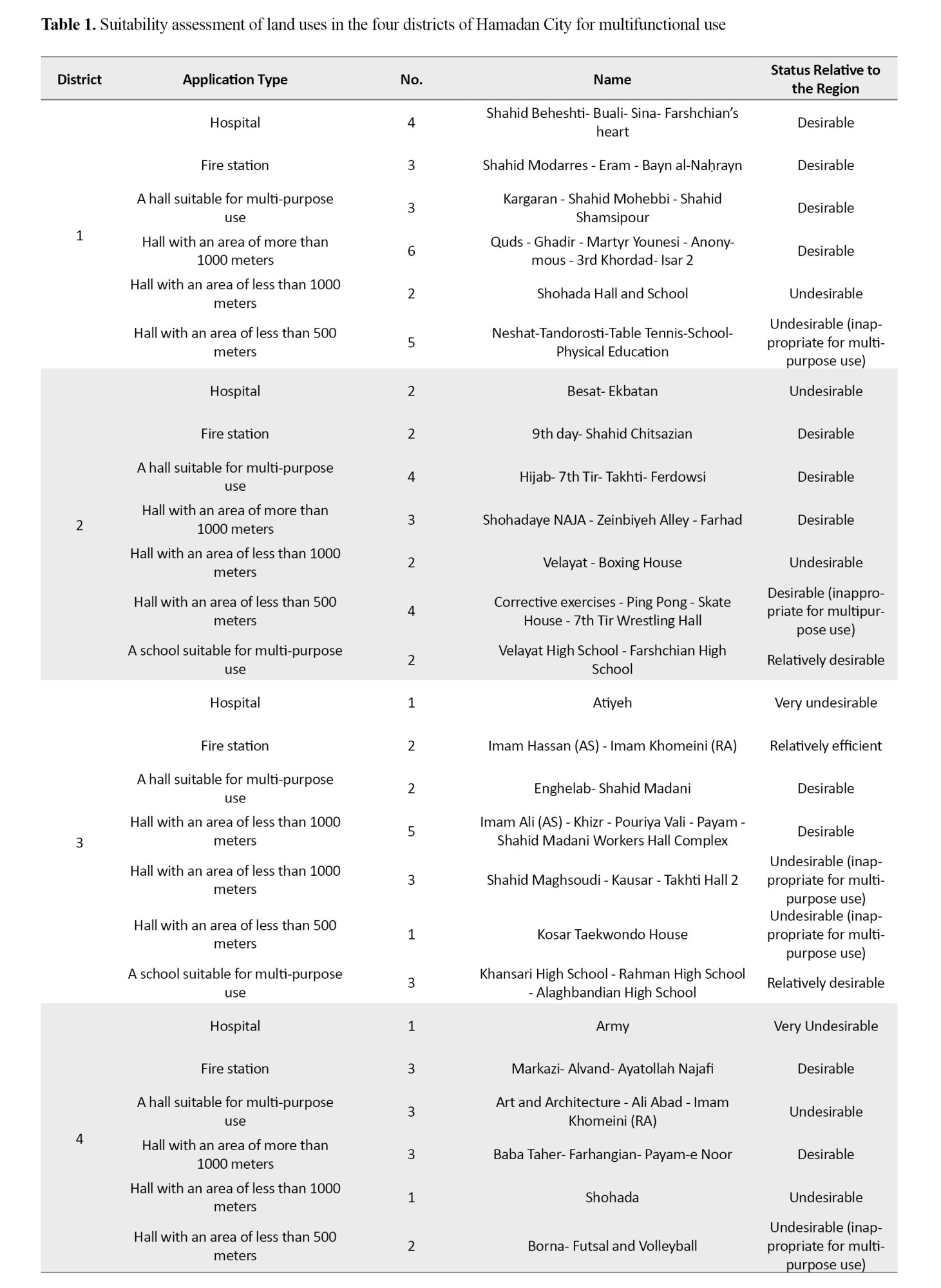
The most important suitability criteria include rapid access to main routes in the shortest time, an appropriate distance from natural hazards, sufficient separation from hazardous facilities, access to social services, and suitable land slope. As can be observed, the existing fire stations and hospitals showed favorable conditions in terms of the coverage neighborhoods and their spatial distribution across the city. However, in some areas, due to changes in urban infrastructure and numerous traffic and crowding issues involving passengers and tourists during particular times of the year, service delivery may be delayed and slowed.
Based on
Table 2, the 6,000-seat Enqelab Hall—being the largest sports facility in Hamadan—can serve as an appropriate location for temporary accommodation of vulnerable groups, provided that suitable measures are implemented and minor deficiencies are addressed.
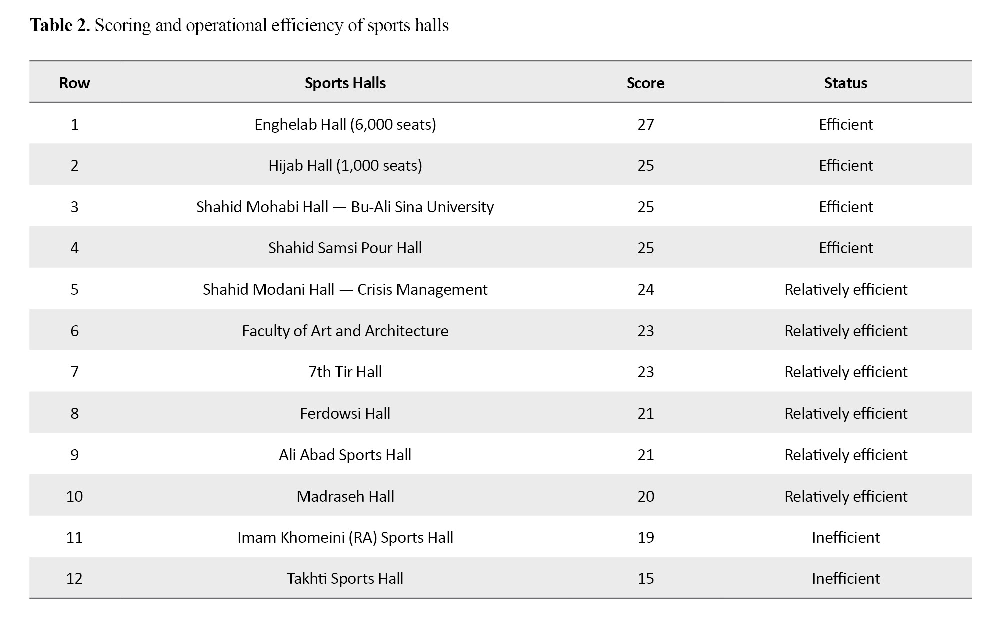
Another suitable facility is the Shahid Shemsi-Poor Hall, which includes several sports halls (suleh complexes), a large grass field, an open yard area sufficient for parking, and a suitable dormitory constructed as an apartment hotel. The 1,000-seat Hijab Hall, as the next appropriate structure, has an open area for linear tent placement, as well as the sports hall yard, enabling a multifunctional setup. The Shahid Mohebbi Hall within the Bu-Ali Sina University campus may also, with the required arrangements, provide suitable conditions for multifunctional use and emergency accommodation. Regarding other facilities, the status is as follows: six halls are in a relatively efficient condition, and two halls are in an inefficient condition (
Table 2).
Based on
Table 3, the central station—equipped with up-to-date hardware facilities and suitable training/educational resources—is a desirable urban fire station.
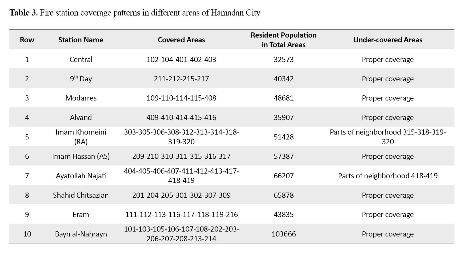
However, the other stations require further review and upgrading of technical and vehicle equipment. Therefore, with the increasing construction of structures and high-rise urban developments, Hamadan is in an unfavorable condition regarding the equipment and capabilities of fire stations compared with large cities and metropolitan areas, and it requires heightened attention from the relevant authorities. Districts 1 and 4, each with three stations, have the highest level of fire coverage, while Districts 2 and 3, each with two stations, have the lowest level of fire coverage. In addition, since the Farhangian residential complex has a high resident population and is located within the county’s busiest transportation corridors, it faces extensive infrastructure changes such as bridges and access roads. Consequently, Fire Station No. 17 on Ayatollah Najafi Boulevard does not provide coverage to all areas with rapid response, and the addition of an auxiliary station is recommended to improve the quality of service delivery (
Table 3).
Based on
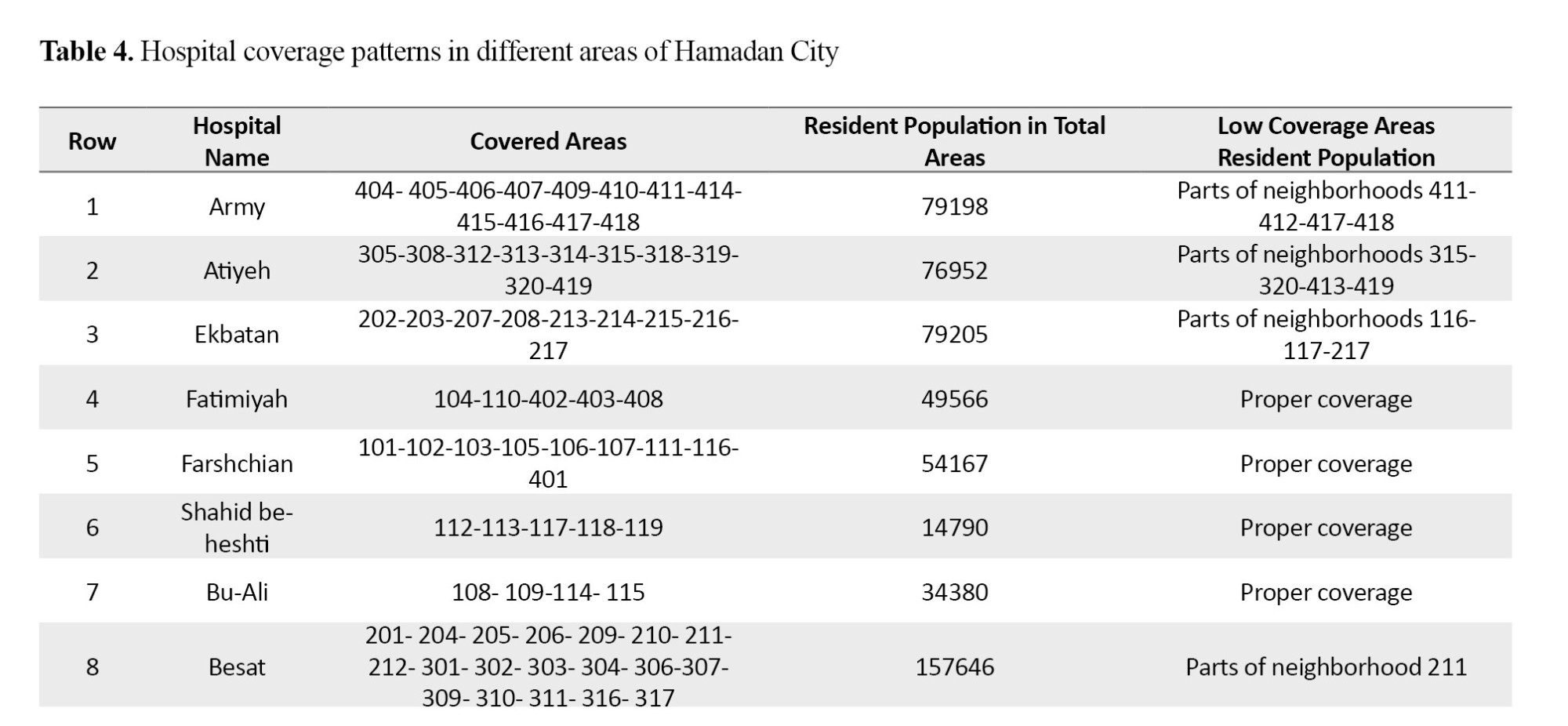
Table 4, it appears that if the emergency departments of the Army and Atiyeh hospitals are expanded, it would be possible to respond with adequate performance during crises, and in general—considering their location relative to multifunctional facilities—they have favorable conditions.
 Discussion
This study aimed to assess the level of suitability of existing urban multifunctional spaces in the crisis management of Hamadan city. The suitability of multifunctional land uses in four urban districts of Hamadan was evaluated separately. Among the 12 assessed halls, only 5 achieved higher scores than the other structures regarding location siting, and—by implementing the necessary measures in the response phase—they can be effective during crises. Although it can be stated that District 4 does not have adequate coverage of multifunctional sports facilities.
Based on the assessment of 12 sports halls for appropriate response capacity in emergency and crisis conditions, there are 4 efficient halls, 6 relatively efficient halls, and 2 inefficient halls. During crises, by implementing the necessary measures in the response phase, these halls can be effective. The operational and feasible functions in this area include providing pre-hospital and hospital services, search and rescue and capability-building, delivery of food, clothing, and pharmaceutical services, and supporting vulnerable groups such as children, persons with disabilities, the elderly, and pregnant mothers.
In the conducted study, considering that among the 12 examined sports halls, only 4 halls (about one-third) had the capacity for multifunctional use during crises, this indicates that the current capacity for using sports halls as a support/back-up space in emergency conditions is limited. In the event of a large-scale crisis, full response to the accommodation or support needs of the affected population would not be possible. This limitation may lead to bottlenecks in emergency service delivery in areas with higher population density or a higher probability of incidents. Furthermore, if the geographical distribution of these halls is unbalanced, the likelihood of coverage gaps for services in some areas will increase.
On the other hand, the existence of these four equipped halls provides a baseline for developing multifunctional capacities in other sports facilities. With targeted planning, the experiences and infrastructure of these halls can be used to upgrade other spaces, thereby establishing a wider network of preparedness facilities for crisis conditions. This action not only enhances urban resilience, but also enables faster and more effective response to natural and human-made hazards. Investment in this area—particularly in equipping facilities with emergency power systems, improving sanitation facilities, and creating safe access routes—can make a significant contribution to reducing damages and accelerating the return to normal conditions.
This section of the study was aligned with the research conducted by Ahmadi Chekulaei et al., who concluded that, among 15 sports halls examined in Tehran, only 6 were efficient (Ahmadi Chekulaei et al., 2023). In addition, consistent with the findings of the present study, Esmailian et al. state that more than half of the sports halls in Semnan lack multifunctional use in crisis situations (Esmailian et al., 2021).
Based on the assessments carried out, in some parts of the urban districts, fire stations and hospital structures are associated with insufficient coverage due to changes in urban infrastructure and traffic flow. Therefore, establishing a back-up fire station along Airport Boulevard and in the areas behind the Farhangian residential complex is recommended. Likewise, regarding hospitals, by expanding the emergency departments of the Army and Atiyeh hospitals, it would be possible to respond with adequate performance during crises; overall, considering their siting relative to multifunctional facilities, they are in favorable conditions. In this regard, Basoli et al., who conducted a study on the relationship between crisis management and the resilience of the host society in the tourism destination of Hamadan, also writes that fire stations in parts of Hamadan are characterized by inadequate coverage due to urban infrastructure changes (Basouli et al., 2021).
One of the main limitations of this study is its focus on a limited number of publicly owned sports facilities, which may not be able to provide a fully representative picture of the actual capacity of multifunctional spaces across Hamadan. In addition, due to time constraints and limited access, it was not possible to conduct a detailed examination of some functional aspects of these spaces during crises (e.g., simulation of crisis conditions, citizen participation, or evaluation of the quality of health and security services). Another challenge is the lack of complete access to up-to-date information on infrastructures and the scarcity of accurate data in some urban areas, which may affect the comprehensiveness of the findings.
The innovation of this study lies in presenting a more realistic and practical picture of multifunctional spaces in urban crisis management in Hamadan by using spatial data, GIS analysis, and field interviews—rather than relying solely on theoretical studies and abstract models. However, a review of past research indicates that many of those studies were accompanied by limitations, including overreliance on theoretical analyses and insufficient field investigations, focusing on a limited number of facilities and therefore providing an incomplete image of the city’s actual capacity, neglecting the simulation of emergency conditions and citizen participation, and weaknesses in up-to-date infrastructure data, as well as ignoring issues such as equitable spatial distribution and access-route coverage.
By addressing some of these shortcomings and combining analytical and field methods, the present research was able to provide a more comprehensive assessment. Although limitations remain—such as the focus on public sports halls—the results show that upgrading equipment and infrastructure and expanding the capacity of existing spaces can play an important role in enhancing urban resilience. Therefore, this study not only identifies weaknesses in prior research, but also provides a basis for more precise planning and more effective decision-making in the field of urban crisis management.
Conclusion
Based on the results obtained from the assessment of multifunctional spaces in Hamadan, it is recommended that the municipal administration—together with relevant organizations—take action to increase the number of primary multifunctional facilities in areas lacking sufficient coverage (particularly District 4). In addition, establishing or strengthening back-up fire stations in high-risk areas such as the Airport Boulevard corridor and the Farhangian residential complex can play an effective role in enhancing urban resilience. Expanding the emergency departments of the Army and Atiyeh hospitals is also another important measure for improving the city’s preparedness in crisis conditions. Furthermore, it is recommended to raise public awareness of the functions of multifunctional spaces during emergencies through public training sessions and urban drills.
The proposed method in this study enables the Prevention and Crisis Management Organization to identify and select optimal and safe locations for the establishment of crisis-management support bases with greater accuracy and ease, despite the presence of multiple parameters and different values. In this regard, a physical/urban design planning approach (spatial-physical planning) can be considered an important method to reduce the destructive impacts of natural hazards and to create readiness for post-disaster relief and response.
Ethical Considerations
Compliance with ethical guidelines
All ethical principles were observed in this study. Since the research did not include any experiments on human or animal samples, no ethics approval code was required.
Funding
This article was extracted from the master’s thesis of Arash Babaei, approved by the Department of Geography, Payame Noor University, Tehran, Iran. This research did not receive any specific grant from funding agencies in the public, commercial, or not-for profit sectors.
Authors' contributions
Conceptualization, methodology, validation, and supervision: Rudabeh Farhadi; Methodology and analysis: Nafiseh Marsousi; Project administration, investigation, visualization, resources, and writing: Arash Babaei.
Conflicts of interest
The authors reported no conflicts of interest.
References
Abounacer, R., Rekik, M., & Renaud, J. (2014). An exact solution approach for multi-objective location-transportation problem for disaster response. Computers & Operations Research, 41, 83-93. [DOI:10.1016/j.cor.2013.08.001]
Choukolaei, H.A., Mirani, S.E., Hejazi, M. et al. RETRACTED ARTICLE: A GIS-based crisis management using fuzzy cognitive mapping: PROMETHEE approach (a potential earthquake in Tehran). Soft Comput 30 (Suppl 1), 441 (2026).[Link]
Altay, N., & Green III, W. G. (2024). OR/MS research in disaster operations management. European Journal of Operational Research, 175(1), 475-493. [DOI:10.1016/j.ejor.2005.05.016]
Azadian, S., Shirali, G. A., & Saki, A. (2016). [Validity and reliability of the crisis management assessment questionnaire based on the seven principles of resilience engineering in hospitals (Persian)]. Iran Occupational Health, 13(1), 15–26. [Link]
Basouli, M., & Jabbari, G. (2021). [The Relationship between Crisis Management and Community Resilience in Tourism Destination at Corona Crisis Case Study: Hamadan City (Persian)]. Urban Tourism, 8(1), 33-48. [DOI:10.22059/jut.2021.318782.884]
Borhani, K., Azimzadeh Irani, A., & Elhami, A. H. (2021). [Spatial analysis of multipurpose urban land uses using an integrated MCDM and GIS approach: A case study of emergency shelters in Saravan City (Persian)]. Geographical Information (Sepehr), 29(116), 103–118. [Link]
Christensen, T., Lægreid, P., & Rykkja, L. H. (2019). Organizing for societal security and crisis management: Governance capacity and legitimacy. In P. Lægreid & L. H. Rykkja (Eds.), Societal security and crisis management: Governance Capacity and Legitimacy (pp. 1-23). Cham: Springer International Publishing. [DOI:10.1007/978-3-319-92303-1_1]
Coombs, W. T & Laufer, D. (2019). Global crisis management-current research and future directions. Journal of International Management, 24(3), 199-203. [DOI:10.1016/j.intman.2017.12.003]
Crandall, W. R., Parnell, J. A., & Spillan, J. E. (2021). Crisis management in the new strategy landscape. California: Sage Publications. [Link]
Esmaeilian Nasari, M., Kamyabi, S., & Zand Moghaddam, M. R. (2021). [Management of abandoned urban lands and their organization based on the sustainable urban development model: A case study of Semnan City (Persian)]. New Attitudes in Human Geography, 4(6), 178–189. [Link]
Estelaji, F., Naseri, A., & Zahedi, R. (2023). Evaluation of the performance of vital services in urban crisis management. Advanced Environmental Research and Engineering, 3(4), 1–19. [Link]
Faisal, A., Albrecht, J. N., & Coetzee, W. J. (2020). Renegotiating organisational crisis management in urban tourism: Strategic imperatives of niche construction. International Journal of Tourism Cities, 6(4), 885-905. [DOI:10.1108/IJTC-11-2019-0196]
Fischer, D., Posegga, O., & Fischbach, K. (2016). Communication barriers in crisis management: A literature review. ECIS Proceedings. [Link]
Haaland, H., & Wallevik, H. (2020). Beyond crisis management? The role of Citizen Initiatives for Global Solidarity in humanitarian aid: the case of Lesvos. Third World Quarterly, 40(10), 1869-1883. [DOI:10.1080/01436597.2019.1656060]
He, S., Zhang, M., & Wei, Z. (2020). The state project of crisis management: China’s Shantytown Redevelopment Schemes under state-led financialization. Environment and Planning A: Economy and Space, 52(3), 632-653. [DOI:10.1177/0308518X19882427]
Hu, R. (2021). Smart design: Disruption, crisis, and the reshaping of urban spaces. London: Routledge. [DOI:10.4324/9780367822453]
Lægreid, P., & Rykkja, L. H. (2019). Societal security and crisis management: Governance capacity and legitimacy. New York: Springer. [DOI:10.1007/978-3-319-92303-1]
Maharjan, R., & Hanaoka, S. (2018). A multi-actor multi-objective optimization approach for locating temporary logistics hubs during disaster response. Journal of Humanitarian Logistics and Supply Chain Management, 8(1), 2-21. [DOI:10.1108/JHLSCM-08-2017-0040]
Nizamidou, C., & Vouzas, F. (2018). MHR: Providing a new perspective in HR in terms of crisis management. International Journal of Business Science & Applied Management (IJBSAM), 13(1), 15-25. [DOI:10.69864/ijbsam.13-1.129]
Wolbers, J., Boersma, K., & Groenewegen, P. (2018). Introducing a fragmentation perspective on coordination in crisis management. Organization Studies, 39(11), 1521-1546. [DOI:10.1177/0170840617717095]