Introduction
Floods are among the most common natural disasters and occur in both developed and developing countries, causing significant damage and affecting large populations (Abdollahzadeh and Sharifzadeh, 2023). It accounts for more than one-third of global natural disaster damage, and more than 90% of people affected by floods live in Asia (Sanatkhah, 2024). Floods have diverse social, economic, and environmental consequences that need to be considered in flood risk analyses and crisis management (Azizi et al., 2021). Understanding risks is important for reducing them. Risk assessment is predictive and preventive in nature, and prevention precedes treatment (Moghimi, 2015). Among the fundamental issues in addressing natural disasters, such as floods, in human settlements are crisis management, associated risks, and the reconstruction of affected areas. During risk assessment, crisis management, and post-disaster recovery planning, numerous factors and elements play a role. The interaction and synergy of these factors can have significant effects on various aspects of urban development, especially on the physical structure of cities. After various disasters and the financial and human consequences they cause, important choices are made, including deciding how to manage the crisis, intervene, reconstruct, establish security, and adopt post-disaster recovery policies (Gorgani and Rahimbakhsh, 2004).
The first visible consequence after a disaster is a change in the physical environment. When a disaster, such as a flood, occurs, the structural integrity that holds a city together is disrupted. In addition to disintegration, a set of elements acts individually, and new conditions emerge. These changes may also spread to various social, economic, and managerial areas (Rowland, 1995). Crisis management and post-disaster recovery in the physical domain includes five continuous stages: damage assessment, debris removal, organizing immediate actions, developing a reconstruction plan, and implementing reconstruction operations (Aysan and Davis, 2006).
Disasters are caused by natural, man-made, and technological hazards. Natural hazards are environmental phenomena that can occur at any time and place. The frequency, extent, and severity of these hazards have increased in the last decade (Esmailnezad et al., 2019). Given the unpredictable nature of most natural disasters and the need to make quick and accurate decisions and implement operations, theoretical foundations have given rise to the field of disaster management (Sanatkhah, 2024). Unfortunately, due to negligence, humans have suffered many losses and damages (Asgari, 2018). Global studies on reducing the vulnerability of human habitats to natural disasters, including floods, have become more comprehensive over time. It began with addressing safety and developing seismic regulations and guidelines to ensure building safety, and has gradually expanded to include management approaches (including preparing hazard zoning maps, vulnerability maps, and emergency plans), the physical safety of cities, urban design and planning, and structural retrofitting of buildings.
Iran is among the 10 most disaster-prone countries in the world and is considered among the first in terms of the diversity of natural hazards. Given the country’s geography, more than 31 of the 41 natural disasters identified worldwide are possible to occur in Iran. Given the increasing number of natural disasters in Iran in recent decades, the need to enhance awareness among experts in crisis management, architecture, and post-disaster recovery to design safer, more resilient buildings in disaster-prone areas is evident. Architects can help during the post-disaster recovery phase.
Golestan Province is one of Iran’s provinces with distinctive geographical features. In Bandar-e Gaz County, located in the west of this province, unplanned expansion, especially in the northern areas, is evident. The plan for the physical and spatial development of this county has been stalled for years, and forward-looking risk assessments have been neglected, while construction is proceeding at a rapid pace. The important threats are the imbalance of the urban landscape, the loss of quality agricultural lands, and the need for physical examination and attention to hazards, especially floods. Due to its proximity to Gorgan Bay and two rivers (Jafa-Kandeh in the west and Gaz in the east), railways, high-voltage electricity lines, and gas lines, Bandar-e Gaz County requires special attention in terms of flood risks. Therefore, this study seeks to investigate the feasibility of flood risk assessment and post-disaster reconstruction, particularly with respect to physical aspects, in Bandar-e Gaz County. The research questions are: What are the indicators for flood risk assessment and reimagining disaster management? What factors affect post-flood reconstruction?
Literature review
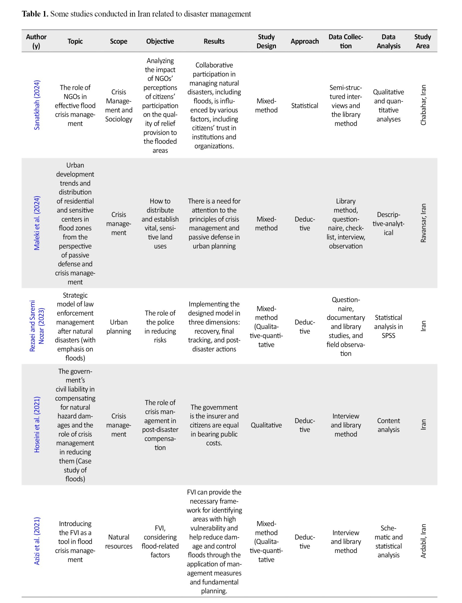
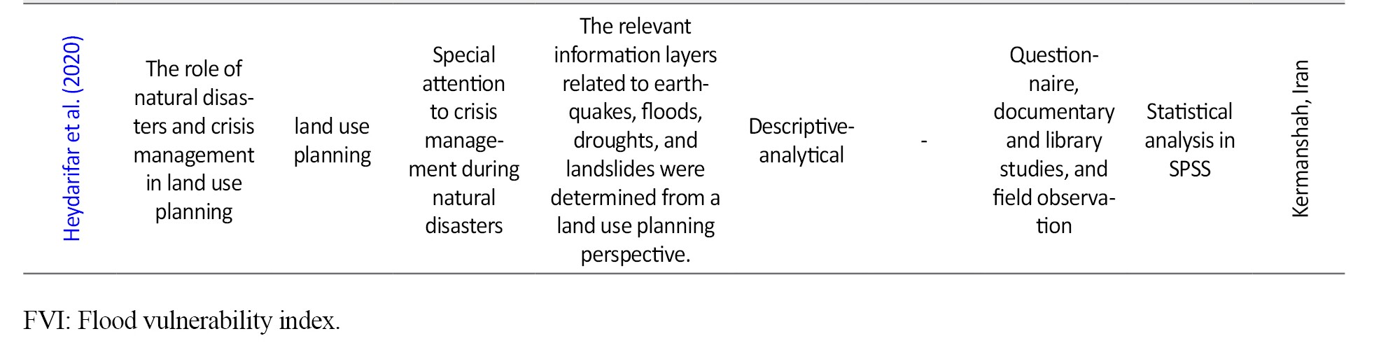
In recent years, some related studies in Iran have been conducted on post-disaster reconstruction, crisis management, and risk assessment (Table 1).
Studies on flood risk management often face limitations in accessing accurate, comprehensive data during the disaster. Field data collection during a disaster is difficult and may be subject to biases arising from the emergency conditions. Also, the generalizability of case study findings to other regions with different climatic, geographical, and socio-economic characteristics may be limited. The lack of longitudinal studies that assess changes in resilience and the effectiveness of disaster management interventions over time is another limitation. Furthermore, the multifaceted nature of floods and their impact on different aspects of life necessitate interdisciplinary approaches that involve collaboration among experts from different fields and the overcoming of challenges arising from differences in language and research methods.
On the other hand, some research in the field of flood risk management may suffer from methodological weaknesses, including a lack of a precise definition of variables, the use of small or non-random samples, and inadequate control for intervening variables. Also, excessive focus on the technical and engineering aspects of flood risk management and neglect of the social, economic, and institutional dimensions can lead to ineffective or unworkable solutions. The lack of coherent, integrated theoretical frameworks in some studies can also hinder the accumulation of knowledge and the comparison of results across studies.
Identifying risk and vulnerability factors and evaluating the effectiveness of disaster management strategies and policies can help identify weaknesses in existing systems and provide evidence-based solutions to improve disaster preparedness, response, and recovery. Quantitative studies using simulation models and advanced statistical analyses enable the prediction of different scenarios and the assessment of potential outcomes. On the other hand, qualitative studies, by examining the experiences of stakeholders and local communities, provide valuable insights into the social, cultural, and institutional dimensions of the disaster, which are important in designing effective interventions tailored to the local context. Combining quantitative and qualitative approaches (mixed-method approach) can provide a more comprehensive understanding of the complexities of flood risk management. In this study, we focus on flood management in Bandar-e Gaz County, which has not been examined in prior studies. Bandar-e Gaz, a port city in Golestan province, is prone to flooding and is of great importance for disaster management.
Theoretical foundations
Disaster
In recent years, most studies on natural disasters have undergone a fundamental shift from the traditional “loss and damage reduction” model to a more comprehensive disaster management paradigm grounded in social systems and social problem-solving approaches. The sustainable livelihoods approach, as one of these new paradigms, emphasizes empowering local residents to create resilient communities capable of recovering from the adverse consequences of hazardous events, rather than focusing solely on reducing losses. In this study, a disaster is considered as a natural or man-made hazard, or a combination of both, that has the potential to adversely affect human lives, property, activities, or the environment. The extent of these effects varies depending on the physical, environmental, socio-economic, and political characteristics of the society. A disaster disrupts the functioning of the main system or its components and undermines its stability. According to the international strategy for disaster reduction (ISDR), “disaster is a serious disruption of a community or a society functioning, causing widespread human, material, economic and/or environmental losses which exceed the ability of the affected community or society to cope using its own resources” (Fainstein, 2003).
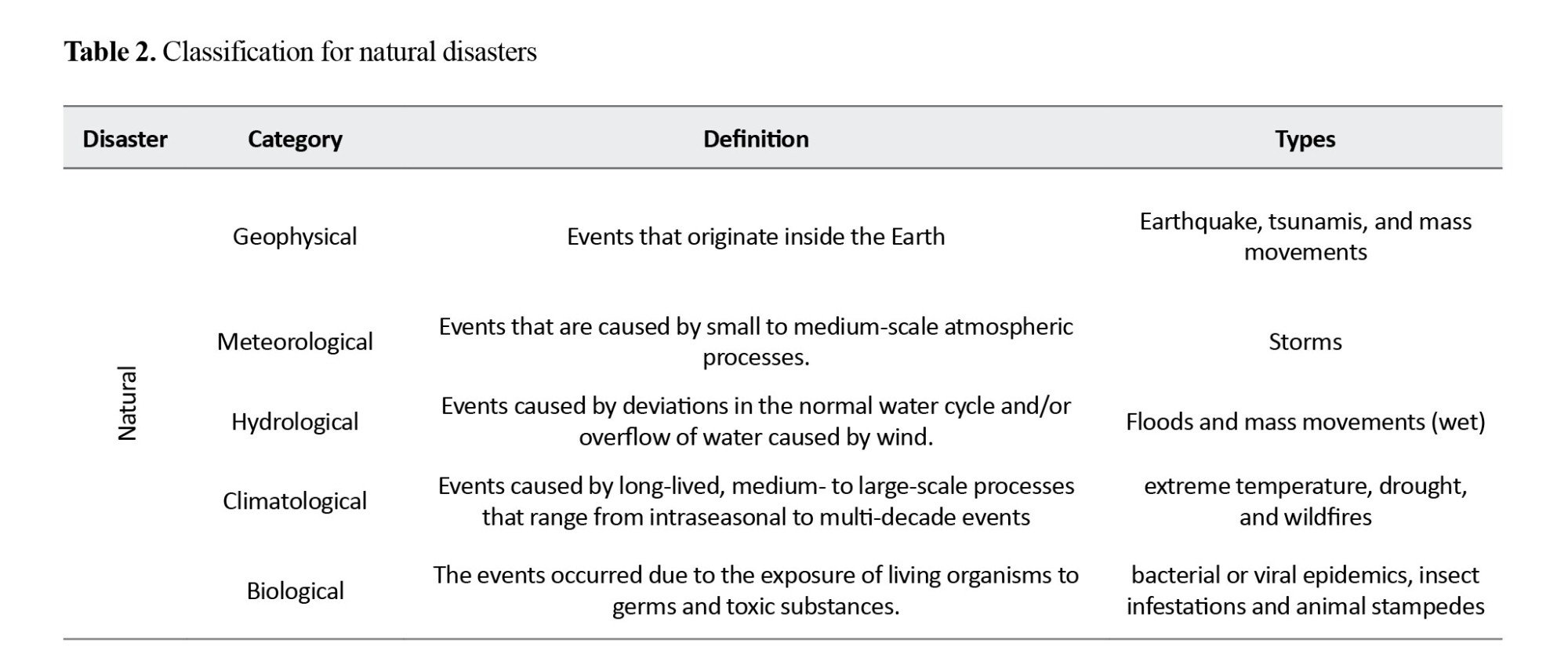
According to the international disaster database, during 1980-1998 and 1999-2009, the number of reported disasters worldwide increased from 1,690 to 3,886. Natural disasters such as floods, earthquakes, volcanic eruptions, storms, and tornadoes are typically associated with environmental damage and human losses, particularly in rural areas. Natural disasters are classified as shown in Table 2. Natural disasters cause the disruption of the lives of people, death, injury, adverse health effects, destruction or damage to governmental systems, buildings, communications and basic infrastructure services (Wisner and Adams, 2002). Natural disasters are quantified by physical damage, expressed in terms of location, intensity, frequency, and probability. Disaster vulnerability is defined by the level of exposure or susceptibility (Table 2).
 Disaster management
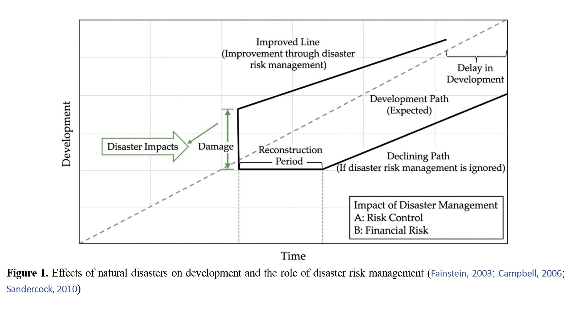
The effect of natural disasters on the development of a region is illustrated in Figure 1. In this figure, the dotted line on the expected development path indicates the goals that planners aim to achieve in the long term. The thick solid line (decreasing trend line) depicts the development pattern affected by the natural disaster. Therefore, the effects of disasters can be mitigated by emphasizing disaster risk management. The improvement achieved through disaster risk management is shown by a thin solid line (increasing trend line), indicating the reduction in damage levels and the expected length of the recovery period through risk control (e.g. discounts) and mitigation of financial risks (e.g. insurance, disaster funds).
According to experts, disaster management encompasses a broad range of planning measures, such as prevention, warning, relief and rescue, emergency assistance, rehabilitation, and reconstruction of areas affected by natural disasters. In other words, disaster management should address the multiple elements of vulnerability (exposure and sensitivity) through structural and non-structural measures, as part of an integrated, sustainable development strategy, guided by cost-benefit analysis. Considering the relationship between sustainable development and disaster risk reduction, the disaster management cycle was proposed as a principle. As depicted in Figure 2, it is a normative model for appropriate planning in a continuous process after a disaster. Its goal is to demonstrate that the impacts of disasters can be reduced through prevention and preparedness measures (both linked to development), while the humanitarian response following a disaster seeks to reduce the consequences of disasters through measures such as rehabilitation and reconstruction activities.
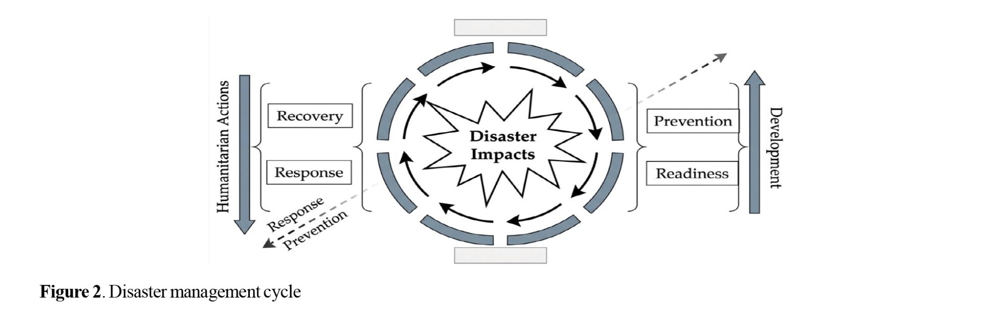
The concept of disaster risk reduction encompasses measures aimed at minimizing the destructive consequences and disruptions caused by disasters. The measures include a wide range of physical, legal, and educational activities that are applied in the pre-, during, and post-disaster phases, each of which requires a different range of disaster response activities. Therefore, the following five important stages will be discussed in the disaster management process: (a) pre-disaster stage: disaster detection (disaster is a function of exposure to hazard, vulnerability, and elements at risk, the effects of which are seen in a certain period of time and a geographical area), disaster preparedness, and risk mitigation. (B) Post- disaster stage: emergency response and reconstruction. According to Freeman, pre-disaster measures include risk transfer (e.g. insurance), risk assessment (surveillance, map production, etc.), risk mitigation activities (such as infrastructure upgrades and reinforcement), and preparedness. Post-disaster measures include emergency response (e.g. emergency relief, cleanup), rehabilitation, reconstruction, and compensatory activities (e.g. national-local contingency funds). In addition to these measures, support or protection can also be mentioned, which is within the two pre- and post-disaster risk management stages. Protection refers to an emergency response network to avoid disaster and crisis situations, which is known as “preparedness”. Preparedness is the ability to manage before a disaster occurs to provide an effective response to the disaster. Protection is ensured by government planning privileges that support social institutions (social support), which are complementary measures to self-protection.
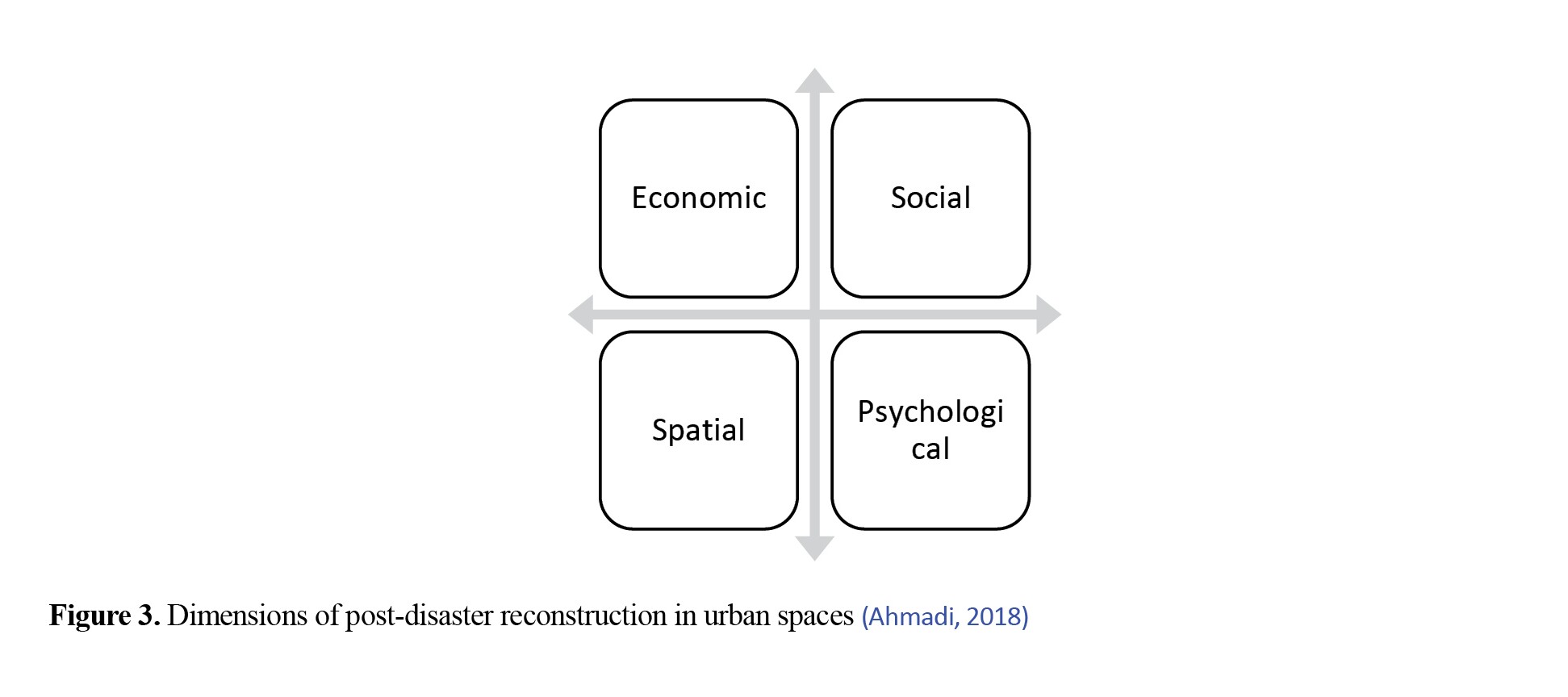
Various dimensions of post-disaster reconstruction in urban spaces include
Spatial
This dimension focuses on the recovery of the physical/spatial structure of cities and includes the reconstruction of places, lands, and buildings (i.e. physical infrastructure of the city);
Social
This dimension is mainly focused on reinforcing previous social values in the urban context, ensuring the security of citizens, and enhancing their participation in the reconstruction process;
Economic
This dimension refers to creating and providing the necessary facilities and platforms for resuming economic activities that were taking place before the disaster;
Psychological
This dimension includes restoring and healing the mental state of the affected people, eliminating feelings of despair and hopelessness, creating dynamism and vitality among citizens, and restoring life and vitality to urban spaces, which is vital for resuming daily economic and social activities (Figure 3) (Ahmadi, 2018);
One of the most important dimensions of reconstruction is physical reconstruction, in which actions, including demolition, debris removal, cleanup, and rebuilding, are carried out;
Demolition
This stage refers to the set of measures that are carried out before any reconstruction operations, and its goal is to prepare the bed and ground to enable the implementation of future reconstruction plans;
Clean-up and debris removal
The post-disaster cleanup process involves collecting debris and waste. The presence of debris and waste has a negative psychological impact on people and delays their return to the city. Therefore, to begin reconstruction, the urban environment must first be cleared of debris and waste. This action brings positive results, such as security for starting reconstruction, accelerating the reconstruction work, implementing the reconstruction plans, and attracting more people to urban spaces (Ahmadi, 2020);
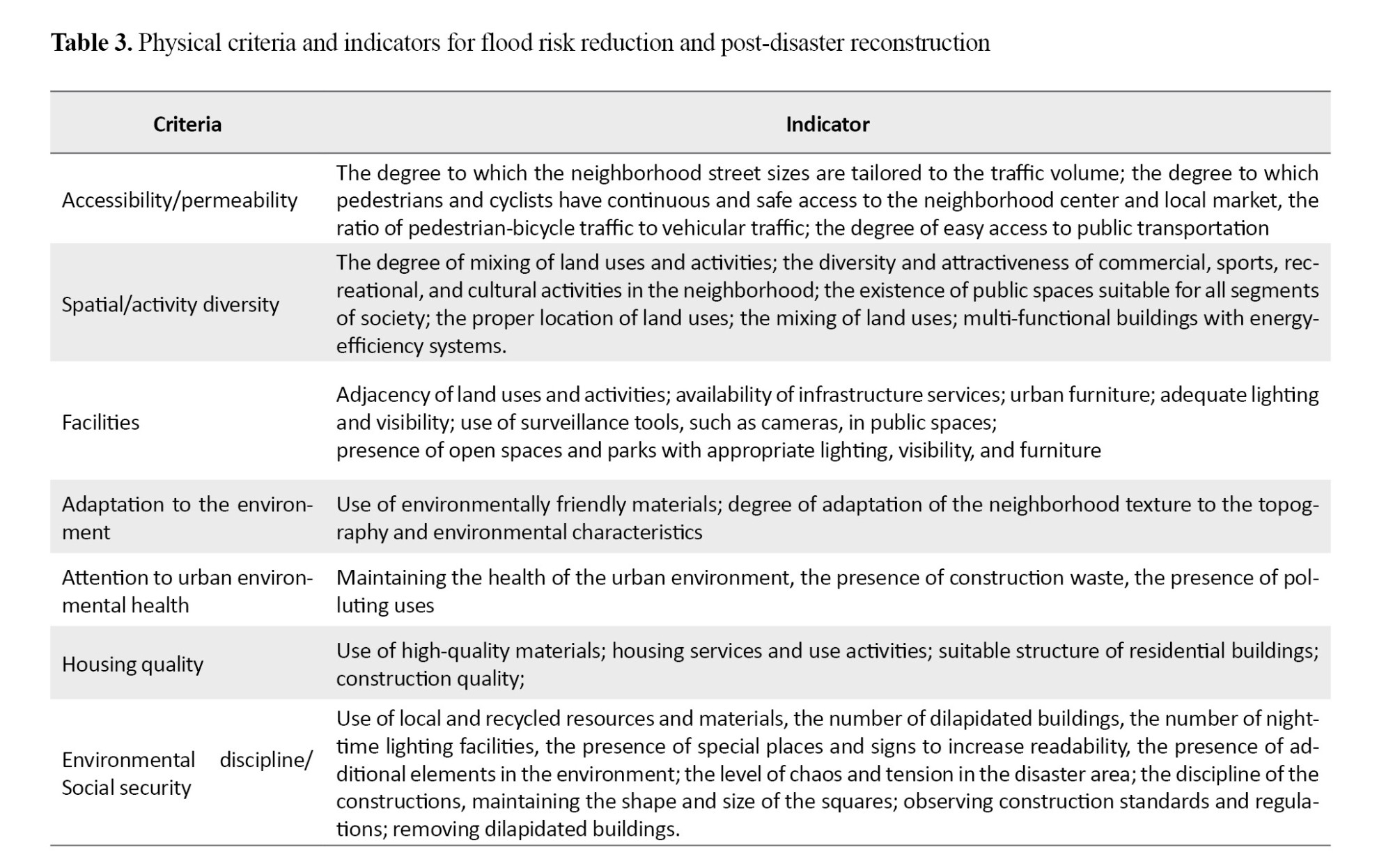
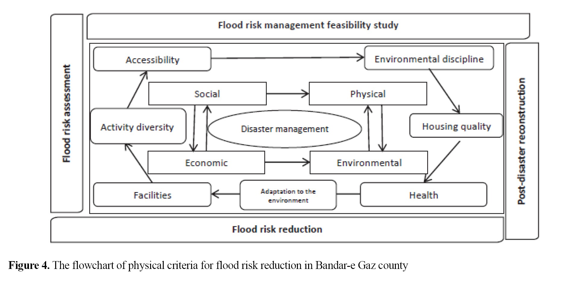
8) Rebuilding: This term refers to a process of reconstruction that can be based on the previous spatial organization or an innovative approach, and create a new spatial organization based on contemporary values, criteria, and standards that are adaptable to future needs (Shamaei and Pour Ahmad, 2005). Based on the theoretical foundations and the synthesis of existing criteria, the physical criteria and sub-criteria for flood risk feasibility assessment and disaster management revision are presented in Table 3 and Figure 4.
 Materials and Methods
Study area
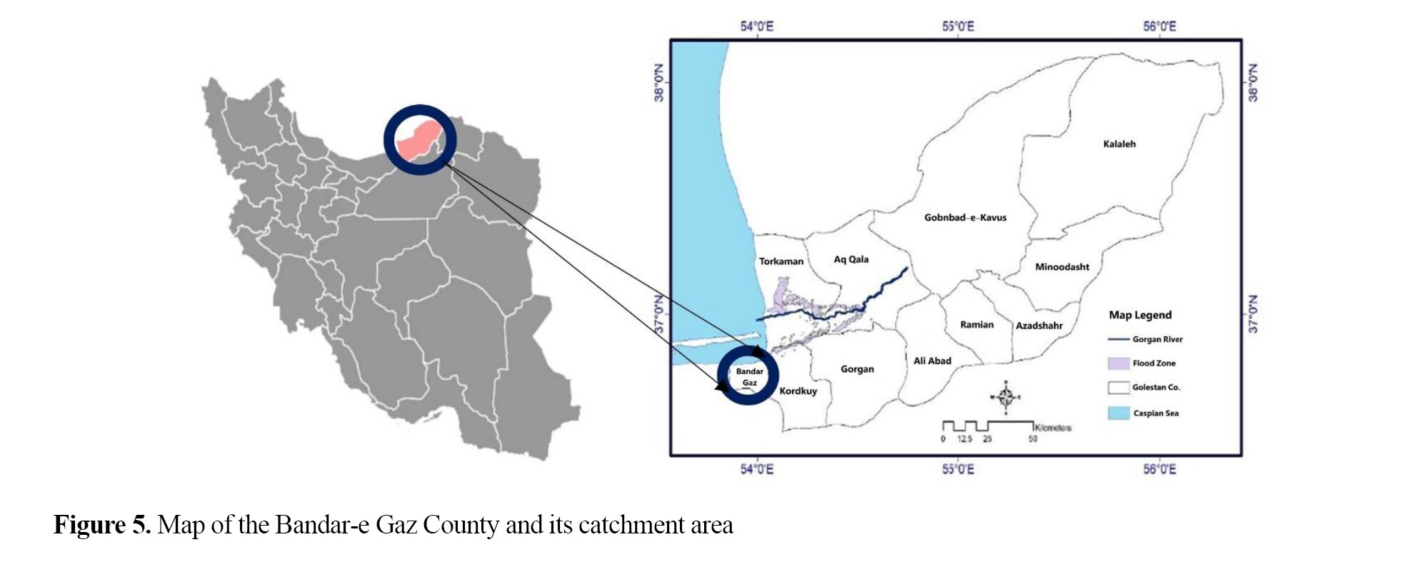
Golestan Province, with an area of 20,437.74 square kilometers, is located in the northeastern part of Iran (53° 57’ to 56° 22’ E and 36° 30’ to 38° 8’ N) and along the southeastern coast of the Caspian Sea. The province borders Turkmenistan to the north, Semnan Province to the south, North Khorasan Province to the east, and Mazandaran Province and the Caspian Sea to the west. Bandar-e Gaz County, located in the western part of Golestan Province, consists of two parts and includes 2 cities, 4 rural districts, and 25 inhabited villages (Figure 5).
 Study design, participants, data collection, data analysis
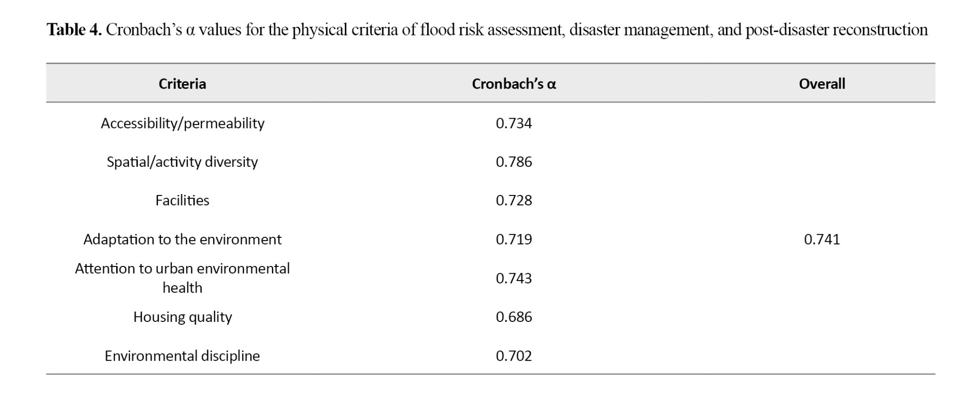
This is a descriptive-analytical mixed-method study (quantitative-qualitative) with an exploratory sequential approach. Participants were 30 experts in architecture, crisis management, and post-disaster reconstruction, and 270 citizens of Bandar-e Gaz. The sampling was done with a simple random method. The required data were collected by a questionnaire. The content validity of this questionnaire was confirmed using the Delphi method and based on the opinions of professors and experts in the fields of architecture, urban planning, and crisis management. The questions are answered based on three options: “essential”, “useful but not essential”, and “not essential.” Researchers such as Alexander et al. have suggested that 67% of the scores assigned to each criterion by experts should be used as the basis for their selection. The score in our study was between 1.5 and 8.5. By calculating two-thirds of the distance between these two points, the value 6.2 was obtained, which was set as a threshold for selecting components in this study. To determine the reliability of the tool, the Cronbach’s α coefficient for all physical criteria of flood risk assessment, disaster management, and post-disaster reconstruction was greater than 0.6, which was acceptable (Table 4). The collected data were analyzed using descriptive and inferential statistics, including factor analysis, regression analysis, and the Pearson correlation test, in SPSS software, version 28 and LISREL software, version.8.8.
 Results
Descriptive findings
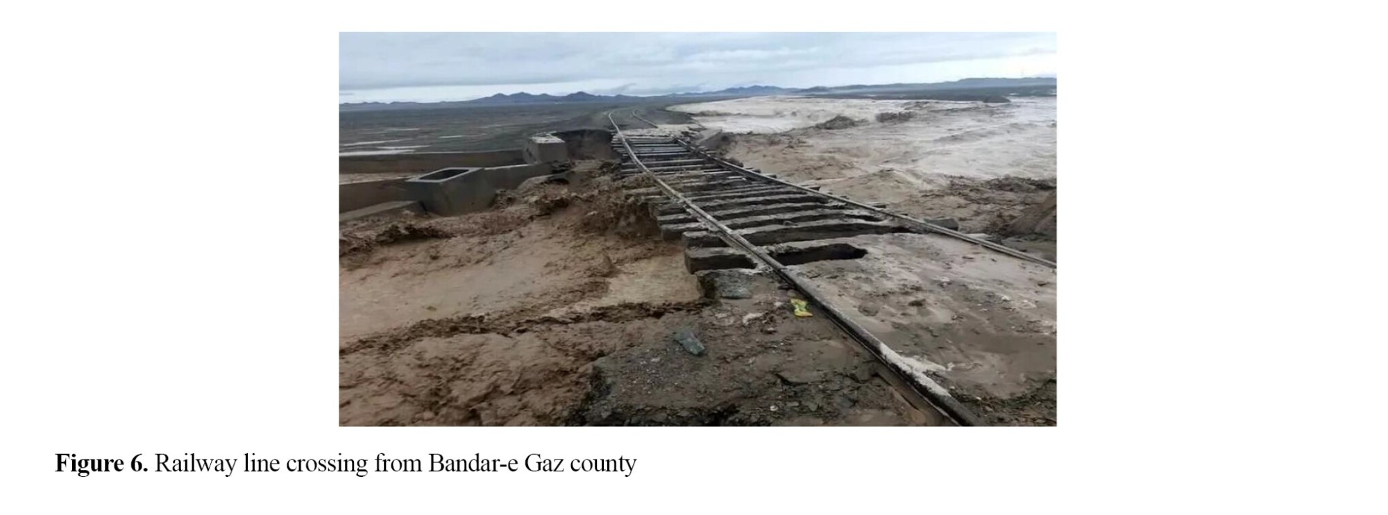
Due to the inherent limitations of the development plan and the absence of a master plan for many years, which led to a lack of continuity and disorganization in the city structure, disaster management in Bandar-e Gaz County was gradually neglected. Given the county’s distance from the fault, earthquake risk is of secondary importance. However, natural and man-made limitations have made this county sensitive to flood risk. Additionally, the presence of high-voltage power lines, gas pipelines, and railways that pass through the county poses a risk to flood management. Additionally, the presence of rivers within the county and the low topography increase the city’s susceptibility to floods.
According to field observations and conversations with the residents, the most important problems of Bandar-e Gaz County included: Poverty, unemployment, immigration, insecurity, the prevalence of social harms, existence of defenseless and crime-prone spaces, the interconnectedness of the city fabric, instability/low quality of housing, lack of urban permeability, roughness of roads and lack of road asphalt pavement, poor lighting of roadways, poor infrastructure services (such as drinking water and lack of a sewage system), ponding of the roadways, unsanitary public spaces, lack of health-care facilities, low quality public transportation, lack of educational, sports, recreational, cultural, administrative, law enforcement, commercial services, and lack of green space.
Factors that limit disaster management in Bandar-e Gaz County included: The railway line that passes through the center of the county, the Sari-Tehran highway that passes through the southernmost part of the county, existence of high-voltage power and gas lines from the south to the north of the county at a distance of approximately 500 meters, heterogeneity of the urban texture, existence of abandoned buildings and wasteland within the county.
The characteristics of the experts are presented in Table 2. All identified criteria and indicators were confirmed based on the opinions of the panel of experts for assessing the post-flood reconstruction of urban spaces in Bandar-e Gaz County (Figure 6).
 Analytical findings
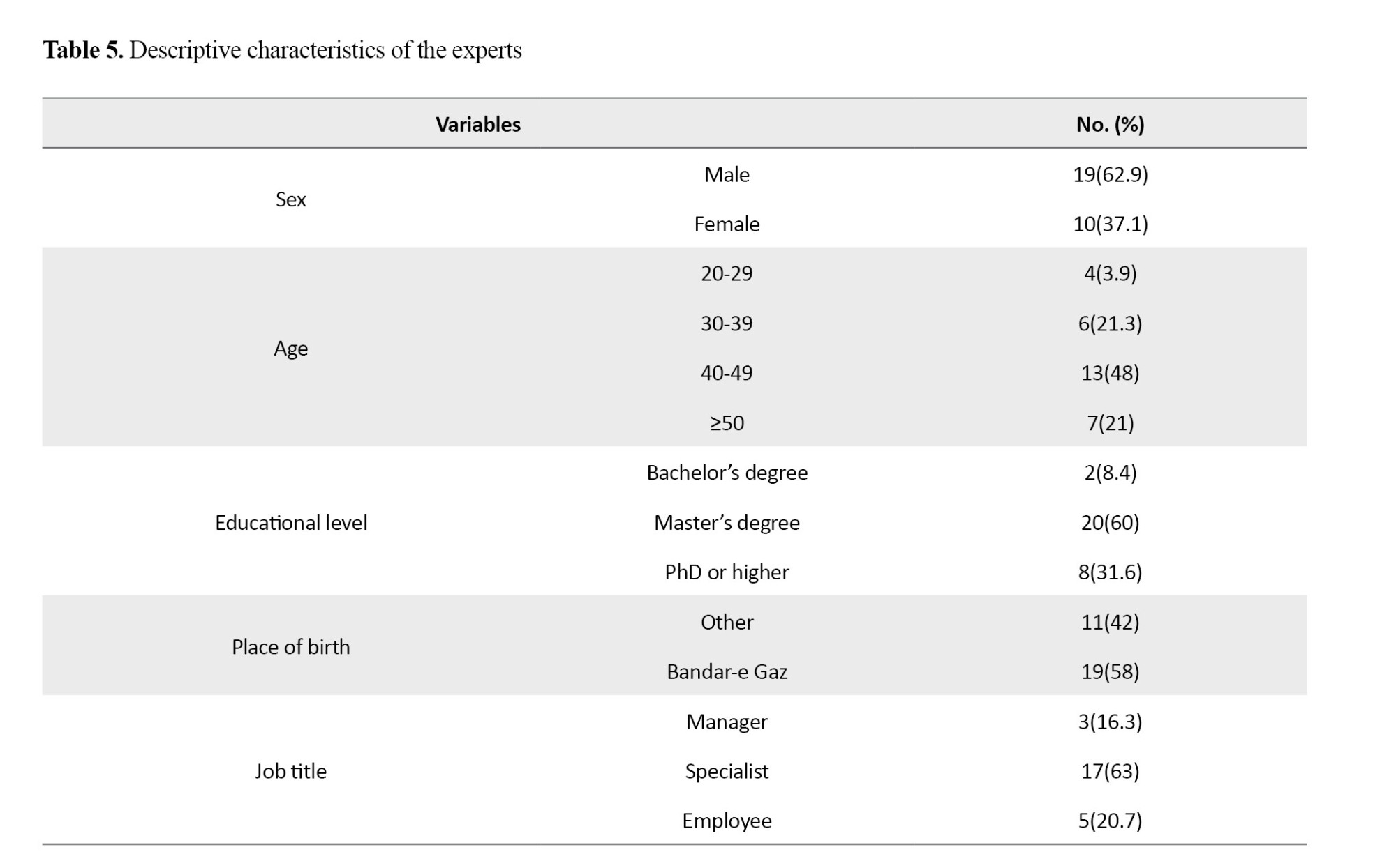
The questionnaire was distributed among a random sample of 30 experts in the fields of architecture, crisis management, urban planning, and post-disaster reconstruction. Descriptive statistics, including the personal characteristics of the respondents, are presented in Table 5.
To validate the dimensions and components of flood risk feasibility and disaster management revision, a Delphi questionnaire was employed. This questionnaire was scored based on three options: 'essential,' 'useful but not essential,' and 'not essential. Following consensus on the evaluation criteria, it was necessary to determine a specific threshold for selecting the components of flood risk feasibility and disaster management revision. In previous studies, researchers such as Alexander et al. have suggested that two-thirds or 67% of the scores assigned to the criteria by experts should be considered as the basis for their selection.
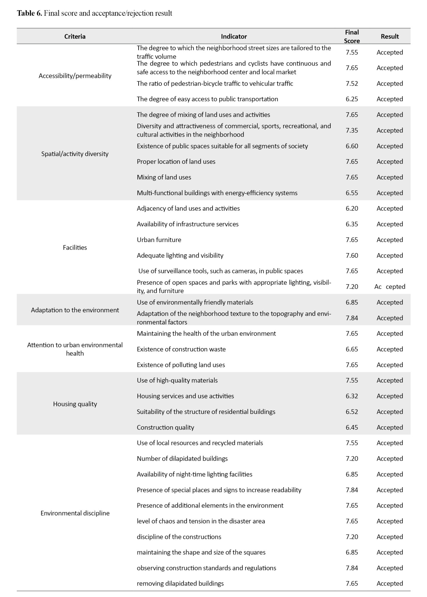
In this specific study, the range of expert scores was between 1.5 (minimum) and 8.5 (maximum). By calculating two-thirds of the distance between these two points, a value of 6.2 was obtained. Accordingly, the acceptable score threshold for selecting components in this study was set at 6.2. Ultimately, all the following indicators were selected as physical indicators affecting the sense of security in the post-disaster reconstruction of urban neighborhoods (Table 6).
Structural equation modeling (SEM) was used to assess the interrelationships among the physical criteria of flood risk management and post-disaster reconstruction. The SEM model and the path coefficients are shown in Figure 7.
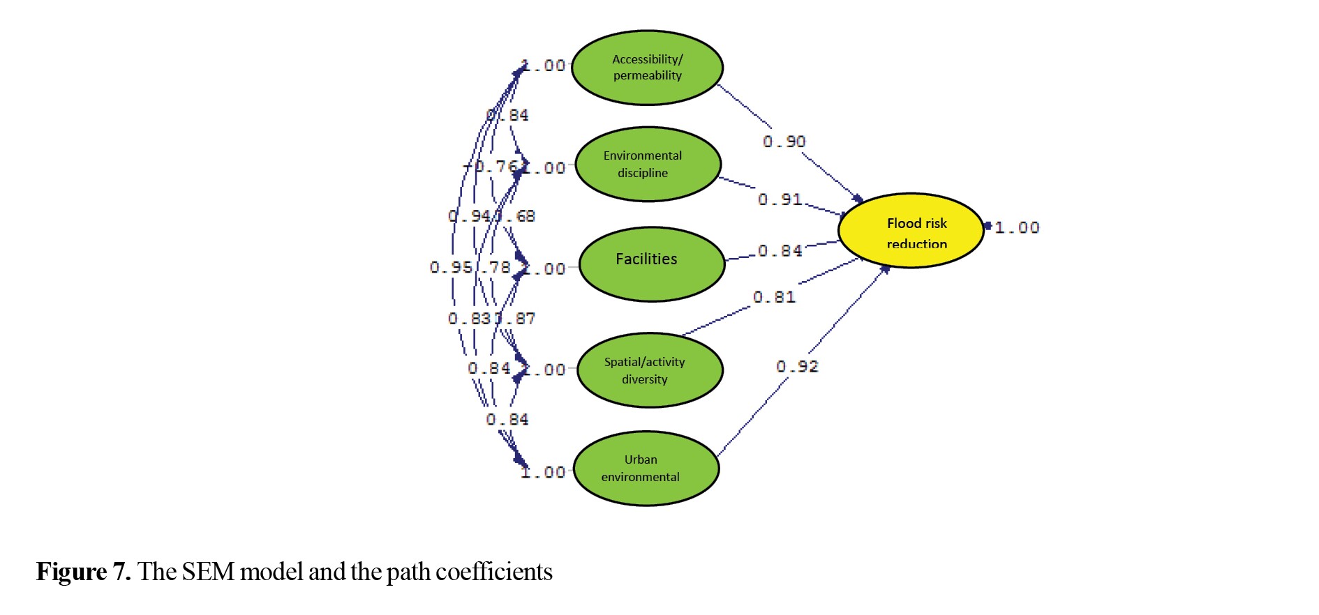
There was a strong, significant relationship among the criteria at the 99% confidence level. This relationship was positive and significant. The RMSEA value was 0.001 and P<0.05, which indicates the goodness of fit of the model. The Pearson correlation matrix confirmed the significant association among the physical criteria (Table 7).
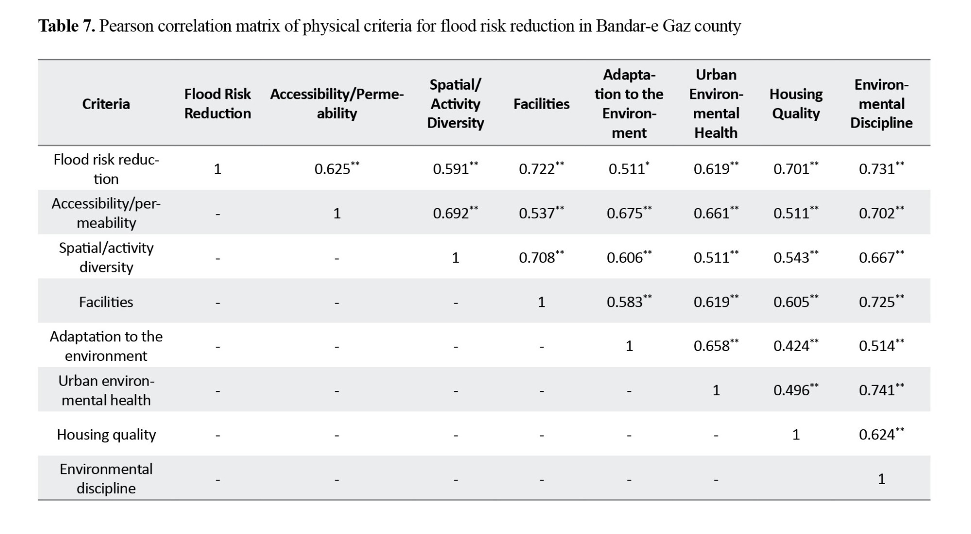
Based on these results, the criteria were ranked as follows: Environmental discipline (0.731), facilities (0.722), Housing quality (0.701), accessibility/permeability (0.625), urban environmental health (0.619), spatial/activity diversity (0.591), and adaptation to the environment (0.511) (Table 7).
Discussion
Delegating specific responsibilities to a designated management entity during a flood, in addition to creating a single, coherent management structure, increases urban sustainability by strengthening resilience to disasters. Therefore, greater coherence and integration in the assignment and performance of flood risk management tasks, as well as post-disaster reconstruction by municipalities and the Crisis Management Organization in urban areas and neighborhoods, can cause coordinated and effective management at different levels of policy-making, planning, and implementation of managerial, spatial-physical affairs, and flood risk reduction. This, in turn, will enhance residents’ sense of security and reduce the risk of loss of life and property from flooding. As a result, residents will be more willing to be present and active in flood risk management. On the other hand, the lack of a coherent management structure for economic, social, cultural, and physical matters leads to incoordination among the responsible organizations and increases risk.
In Bandar-e Gaz County, disaster management at the urban and neighborhood levels has been hampered by the absence of a dedicated management authority, with multiple organizations intervening in these areas, resulting in overlapping duties. Therefore, a non-integrated urban management system cannot be expected to be effective in these areas. Hence, in order to achieve sustainability and reduce flood risks in Bandar-e Gaz, it is necessary to define specific tasks based on the flood risk management feasibility factors, including performance, environmental, social indicators, and to assign these tasks to specific organizations based on their roles and in accordance with the principles of integration and coordination. Such an approach can be considered a prerequisite for successful crisis management, promoting urban sustainability, and reducing vulnerability to disasters such as floods.
Obstacles and limitations to development in Bandar-e Gaz have constrained the performance and efficiency of flood risk management. Therefore, it is necessary to remove these limitations, especially in physical dimensions, to minimize the risk of disasters, especially floods, in this county. The 2022 flood in Bandar-e Gaz (although it did not cause major damage) was a warning sign for the Iranian Crisis Management Organization. In this regard, this study examined the feasibility of flood risk management based on the identified criteria to improve disaster management in Bandar-e Gaz County.
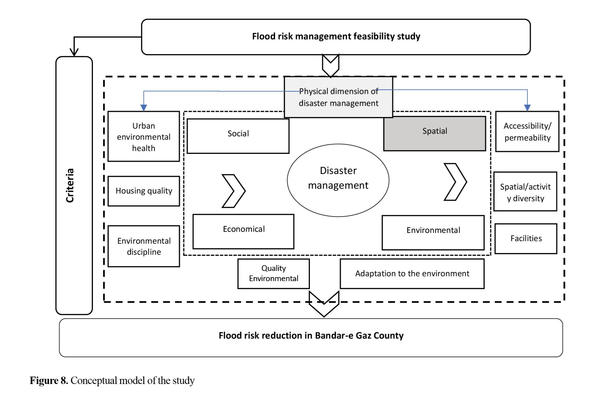
The results of this study are consistent with the results of Rezaei and Nozar (2023). They suggested that implementing the designed model in three dimensions of recovery, final tracking, and post-disaster actions during floods can establish law enforcement and security, and lead to successful disaster management. In our study, physical factors such as environmental discipline were reported to be effective factors in reducing flood risk. In line with the results of Azizi et al. (2021), we considered environmental discipline, housing quality, urban environmental health, environmental adaptation, facilities, physical-activity diversity, accessibility/permeability as physical factors for reducing flood risk and the success of disaster management. The results of our study are consistent with the results of Heidarifar et al. (2020), who showed a relationship between physical factors of disaster management and flood risk reduction in Bandar-e Gaz. In our study, we also found a significant positive correlation between the flood risk reduction criteria in Bandar-e Gaz (Figure 8).
 Conclusion
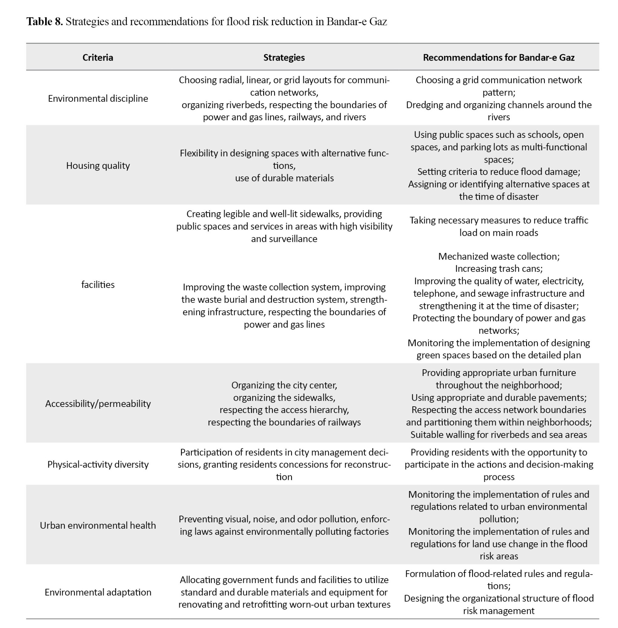
In the future development plans for Bandar-e Gaz, existing limitations in physical dimension of disaster management should be removed and the city’s preparedness against floods should be improved by revising disaster management methods and strengthening seven physical criteria: environmental discipline, housing quality, urban environmental health, environmental adaptation, facilities, physical-activity diversity, and accessibility/permeability. In this regard, all 4 types of strategies (aggressive, adaptive, defensive, and competitive) should be used (Table 8).
 Ethical Considerations
Compliance with ethical guidelines
In this study, all ethical principles were observed. Since no experiments on animal or human samples were conducted, no ethical code was obtained.
Funding
This research did not receive any specific grant from funding agencies in the public, commercial, or not-for-profit sectors.
Authors' contributions
All authors contributed equally to the conception and design of the study, data collection and analysis, interpretation of the results, and drafting of the manuscript. Each author approved the final version of the manuscript for submission.
Conflicts of interest
The authors declared no conflict of interest.
References
Abdollahzadeh, G., & Sharifzadeh, M. S. (2024). [Social integration of immigrants in the business environment (Persian)]. Journal of Entrepreneurship Research (JER), 3(3), 73-86. [DOI:10.22034/jer.2024.2030400.1124]
Ahmadi, H., Rafieian, M., & Owrang, M. (2018). [An introduction to post-disaster reconstruction and the requirements for improving the quality of the residential environment (Persian)]. Paper presented at the 3rd International Conference on Civil Engineering.
Ahmadi, A., & Manoochehri, S. (2020). [Assessing the Status and Analysis of Factors Affecting the Desirability of Crisis Management of Environmental Hazards in Ghaenat City (Persian)]. Spatial Planning, 10(2), 23-56. [DOI:10.22108/SPPL.2020.117853.1398]
Anabestani, A. A., Javanshir, M., & Haghpana, H. (2020). Comparative Analysis of the Effects of Resettlement Patterns After Natural Hazards on the Quality of Rural Life (Case Study: The 1997 Zirkuh Earthquake). Geography and Environmental Hazards, 9(2), 35-41. [Link]
Asgari, A. (2018). [Developing an appropriate strategy for crisis management in District 12 of Tehran Municipality (Persian)] [MA thesis]. Eslamshahr: Islamic Azad University Islamshahr Branch.
Aysan, Y., & Davis, I. (2006). Rehabilitation and reconstruction. Disaster Management Center, Oxford Polytechnic.
Azizi, E., Mostafazadeh, R., Hezbavi, Z., Esmaeli Ouri, A., & Mizaei, S. (2021). Introducing Flood Vulnerability Index (FVI) as a Tool in Flood Crisis Management. Knowledge of Prevention and Crisis Management, 11(2), 158-165. [Link]
Campbell, S. (1996). Green cities, growing cities, just cities? Urban planning and the contradictions of sustainable development. Journal of the American Planning Association, 62(3), 296-312. [DOI:10.1080/01944369608975696]
Davidson, S. (2011). A Review of the IFRC-led Shelter Cluster Haiti 2010. Geneva: International Federation of Red Cross and Red Crescent Societies. [Link]
Davis, I. (2012). What is the vision for sheltering and housing in Haiti? Summary Observations of Reconstruction Progress following the Haiti Earthquake of January 12th 2010. [Link]
Eamaeilnezad, M., Karimi, S., & Khabazi, S. (2019). [Synergism and Spatial Zoning of Natural Hazards (Case Study: South Khorasan Province) (Persian)]. Physical Geography Quarterly, 44(12), 99-118. [Link]
Fainstein, S. S. (2003). Planning and the Just City. In V. Campbell & S. S. Fainstein (Eds.), Readings in Planning Theory. New Jersey: Wiley-Blackwell. [Link]
Fotouhi, S., & Kiani, S. (2015). [Micro-Zoning of Urban Flood Risk Using the Analytical Hierarchy Process Model: A Case Study of Nahavand City (Persian)]. Journal of Environmental Planning and Management, 29(8), 152. [Link]
Fallahi, A. (2012). [Various Approaches to Post-Disaster Housing Reconstruction: From Birth to Maturity (Persian)]. Soffeh, 21(2), 125-136. [Link]
Fujita, K. (2009). Urban justice and Sustainability. Local Environment, 14(5). [DOI:10.1080/13549830902903641]
Gholami, Gh., Sarvar, R., & Tavakkolan, A. (2023). [Evaluation and Spatial Assessment of Sustainable Urban Development with Healthy City Approach in Tehran Metropolis (Persian)]. Geographical Research Quarterly, 3(38), 401-410. [Link]
Gorgani, M., & Rahimbakhsh, H. (2004). [Post-disaster reconstruction policies and their impact on urban physical structure (Persian)]. Journal of Housing and Rural Environment.
Gilbert, A., & Chakraborty, J. (2011). Using geographically weighted regression for environmental justice analysis: Cumulative cancer risks from air toxics in Florida. Social Science Research, 273- 286. [DOI:10.1016/j.ssresearch.2010.08.006]
Harvey, D. (1979). On planning the ideology of planning. In R. A. Burchell & G. Sternlieb (Eds.), Planning theory in the 1980s: A search for future directions (pp. 213–233). Center for Urban Policy Research, Rutgers University. [Link]
Heidari Far, M. R., Soleimani Rad, E., & Hosseini Siahgoli, M. (2020). [Investigating the role of natural hazards and crisis management in land use planning: A case study of Kermanshah Province (Persian)]. Quarterly Journal of Sustainable Urban and Regional Development Studies, 1(1), 55–76. [Link]
Hellegers, S., (2021), Justice and Mobilities in the Netherlands [MA Thesis]. Nijmegen: Radboud University. [Link]
Hosseini Zahmatkesh, R. S., Vaziri, M., & Yaghouti, I. (2021). Investigating the Civil Responsibility of the Government in Compensating Damages of Natural Hazards and the Role of Crisis Management in Reducing It (Case Study: Flood). Iranian Journal of Medical Law, 15(3), 621-630. [Link]
Iveson, K. (2011). Social or Spatial justice? Marcuse and Soja, on the right to the city. City, 15(2). [DOI:10.1080/13604813.2011.568723]
Kanaani, O. (2021). Investigating the Relationship Between Empowerment and Citizens’ Participation in Increasing Urban Resilience and Reducing Vulnerability Caused by Earthquakes. Civil Engineering, Architecture and Urban Development Conference, 3(1), 115-125.
Kasser, J. E. (2019). Systems Engineering: A Systemic and Systematic Methodology for Solving Complex Problems. London: CRC Press. [DOI:10.1201/9780429425936]
Maleki, K., Masoudi Asl, B., Taghipour, A. A., Nastarani, S., & Maleki, Y. (2025). The Trend of Urban Development and Distribution of Vital Land Uses, Accommodation and Sensitive Centers in the Flood Zone from the Perspective of Passive Defense and Crisis Management (Case Study: Ravansar City). Journal of Geography and Land Space Engineering, 9(2). [DOI:10.22034/jget.2024.441312.1540]
Maleki, M. H., Pahkideh, E., Maleki, I., & Maleki, Y. (2023). [An Analysis of the Threat Network and Flood Hazard Cycle in Land Use Vulnerability with an Approach to Passive Defense and Urban Resilience (Case Study: Ravansar City) (Persian)]. Geography and Environmental Studies, 12(45), 52-67. [Link]
Mersal, A. (2016). Eco city Challenge and opportunities in transferring a city in to green city. Procedia Environmental Sciences, 37(2017), 22 - 33. [DOI:10.1016/j.proenv.2017.03.010]
Modiri, A., & Ashrafi Zanjani, A. (2014). [Revitalizing Collective Memories in Post-Natural and Other Disasters Reconstruction Based on Identity and Place (Persian)]. Housing and Rural Environment Magazine, 33(145), 45-62. [Link]
Moghimi, E. (2015). Natural hazards and risk management. University of Tehran Press
Navidi Majd, F., Andalib, A., & Majidi, H. (2020). [Evaluation and Analysis of the Effects of Post-Disaster Reconstruction Elements on the Physical-Spatial Dimension of Cities (Case Study: Manjil City) (Persian)]. Amayesh-e Mohit, 12(46), 199-217. [Link]
Norozi, S., & Javan Forouzandeh, A. (2021). [Analyzing the aspects of participation concept in the process of public space design (Persian)]. Motaleate Shahri, 10(38), 49-62. [Link]
Rezaie, A., & Saremi Nozar, N. A. (2023). [Strategic management model of policing after natural disasters (with an emphasis on floods) (Persian)]. Police Management Studies Quarterly, 18(2), 47–74. [Link]
Rowland, J. R. (1995). Urban planning and management in the aftermath of disasters. Hoboken: Wiley.
Sanatkhah., A. (2025). [Factors Affecting the Participation of Non-governmental Organizations in flood Crisis Management in Iran: A Qualitative Study (Persian)]. Disaster Prevention and Management Knowledge, 14(4):478-495. [DOI:10.32598/DMKP.14.4.874.1]
Sandercock, L. (2010). Towards Cosmopolis: Planning for Multicultural Cities. Hoboken: Wiley. [Link]
Shamaee, A., & Pourahmad, A. (2005). [Urban improvement and renewal from the perspective of geography (Persian)]. University of Tehran Press.
United Nations Office for Disaster Risk Reduction. (2015). Sendai framework for disaster risk reduction 2015–2030. In Proceedings of the 3rd United Nations World Conference on Disaster Risk Reduction, Sendai, Japan. United Nations. [Link]
Walker, J. F. & Alexander, D. (2014). The Post-Disaster Phase of Transitional Settlement: A Perspective from Typhoon Yolanda (Haiyan) In Eastern Philippines. IRDR Special Report 2014-01. London: UCL Institute for Risk and Disaster Reduction. [Link]
Wang, Z. Y. (2010). [The basic structure and challenge of Chinese natural disaster emergency management system (Chinese)]. Emergency Management China, 10, 22–24.
Wisner, B., & Adams, J. (2002). Environmental health in emergencies and disasters: A practical guide. Geneva: World Health Organization (WHO). [Link]
Yahyaei, H., & Kamyabi, S. (2017). [Geographical Management of Populations Affected by Flood and Earthquake (Case Study: Sorkheh County) (Persian)]. GIS (Geographic Information System in Planning), 27(8), 1-12.
Yari, H., & Hezarjaribi, J. (2012). [Investigating the Relationship between Sense of Security and Social Trust among Citizens (Case Study: Residents of Kermanshah City) (Persian)]. Strategic Research on Social Issues of Iran, 1(4), 39-58. [Link]


